
Spenden
Rüste dich für dein nächstes Abenteuer:
Als Amazon-Partner verdient diese Seite an qualifizierten Käufen, ohne dass Ihnen zusätzliche Kosten entstehen.
Topografische Karte Ione
Klicken Sie auf die Karte, um die Höhe anzuzeigen.
Spenden
Rüste dich für dein nächstes Abenteuer:
Als Amazon-Partner verdient diese Seite an qualifizierten Käufen, ohne dass Ihnen zusätzliche Kosten entstehen.
Ione
Ione is situated on the west bank of the Pend Oreille River as it flows north towards Canada. Big Muddy Creek, Little Muddy Creek and Cedar Creek, from south to north, join the river in Ione. State Route 31 passes through town. Ione Bridge, on the southern edge of town, is the only road crossing of the Pend Oreille between Metaline Falls to the north and Usk to the south. Being located in the Selkirk Mountains, the area immediately surrounding Ione is of high topographic relief. The town itself is on a relatively flat area along the river at an elevation of 2,090 feet above sea level, but the mountains rise dramatically both sides of the Pend Oreille. Cement Mountain, with its peak roughly a mile immediately north of town, rises to 3,003 feet. Molybdenite Mountain, across the river from Ione, rises even higher to 6,788 feet.
Spenden
Rüste dich für dein nächstes Abenteuer:
Als Amazon-Partner verdient diese Seite an qualifizierten Käufen, ohne dass Ihnen zusätzliche Kosten entstehen.
Über diese Karte
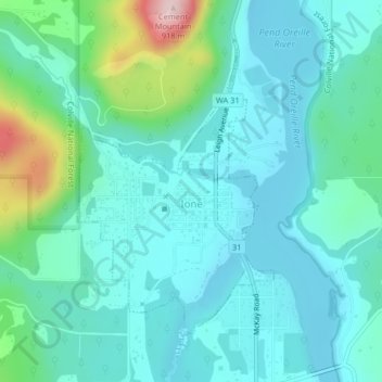
Name: Topografische Karte Ione, Höhe, Relief.
Durchschnittliche Höhe: 670 m
Minimale Höhe: 614 m
Maximale Höhe: 907 m
Spenden
Rüste dich für dein nächstes Abenteuer:
Als Amazon-Partner verdient diese Seite an qualifizierten Käufen, ohne dass Ihnen zusätzliche Kosten entstehen.
Andere topografische Karten
Klicken Sie auf eine Karte, um ihre Topografie, ihre Höhe und ihr Relief anzuzeigen.
Spenden
Rüste dich für dein nächstes Abenteuer:
Als Amazon-Partner verdient diese Seite an qualifizierten Käufen, ohne dass Ihnen zusätzliche Kosten entstehen.