
Spenden
Rüste dich für dein nächstes Abenteuer:
Als Amazon-Partner verdient diese Seite an qualifizierten Käufen, ohne dass Ihnen zusätzliche Kosten entstehen.
Topografische Karte Mill Creek Point
Klicken Sie auf die Karte, um die Höhe anzuzeigen.
Spenden
Rüste dich für dein nächstes Abenteuer:
Als Amazon-Partner verdient diese Seite an qualifizierten Käufen, ohne dass Ihnen zusätzliche Kosten entstehen.
Über diese Karte
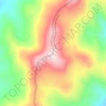
Name: Topografische Karte Mill Creek Point, Höhe, Relief.
Durchschnittliche Höhe: 1’275 m
Minimale Höhe: 1’038 m
Maximale Höhe: 1’498 m
Spenden
Rüste dich für dein nächstes Abenteuer:
Als Amazon-Partner verdient diese Seite an qualifizierten Käufen, ohne dass Ihnen zusätzliche Kosten entstehen.
Andere topografische Karten
Klicken Sie auf eine Karte, um ihre Topografie, ihre Höhe und ihr Relief anzuzeigen.
Ione
United States > Washington > Pend Oreille County
Ione is situated on the west bank of the Pend Oreille River as it flows north towards Canada. Big Muddy Creek, Little Muddy Creek and Cedar Creek, from south to north, join the river in Ione. State Route 31 passes through town. Ione Bridge, on the southern edge of town, is the only road crossing of the Pend…
Durchschnittliche Höhe: 670 m
Newport
United States > Washington > Pend Oreille County
Newport is located at an elevation of 2,160 feet (658.5 m) and according to the United States Census Bureau, the city has a total area of 1.07 square miles (2.77 km2), all of it land.
Durchschnittliche Höhe: 662 m
Kalispel Reservation
United States > Washington > Pend Oreille County > Airway Heights
Durchschnittliche Höhe: 801 m
Ione
United States > Washington > Pend Oreille County
Ione is situated on the west bank of the Pend Oreille River as it flows north towards Canada. Big Muddy Creek, Little Muddy Creek and Cedar Creek, from south to north, join the river in Ione. State Route 31 passes through town. Ione Bridge, on the southern edge of town, is the only road crossing of the Pend…
Durchschnittliche Höhe: 670 m
Spenden
Rüste dich für dein nächstes Abenteuer:
Als Amazon-Partner verdient diese Seite an qualifizierten Käufen, ohne dass Ihnen zusätzliche Kosten entstehen.
Newport
United States > Washington > Pend Oreille County
Newport is located at an elevation of 2,160 feet (658.5 m) and according to the United States Census Bureau, the city has a total area of 1.07 square miles (2.77 km2), all of it land.
Durchschnittliche Höhe: 662 m
Spenden
Rüste dich für dein nächstes Abenteuer:
Als Amazon-Partner verdient diese Seite an qualifizierten Käufen, ohne dass Ihnen zusätzliche Kosten entstehen.