
Topografische Karte Kelstedge
Klicken Sie auf die Karte, um die Höhe anzuzeigen.
Über diese Karte
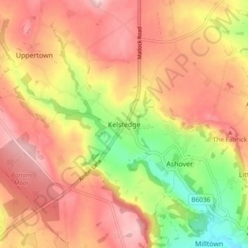
Name: Topografische Karte Kelstedge, Höhe, Relief.
Durchschnittliche Höhe: 246 m
Minimale Höhe: 132 m
Maximale Höhe: 322 m
Andere topografische Karten
Klicken Sie auf eine Karte, um ihre Topografie, ihre Höhe und ihr Relief anzuzeigen.
Clay Cross CP
United Kingdom > England > Derbyshire > North East Derbyshire
Durchschnittliche Höhe: 133 m
Stretton CP
United Kingdom > England > Derbyshire > North East Derbyshire
Durchschnittliche Höhe: 133 m
North Wingfield
United Kingdom > England > Derbyshire > North East Derbyshire
Durchschnittliche Höhe: 126 m
Wingerworth
United Kingdom > England > Derbyshire > North East Derbyshire
Durchschnittliche Höhe: 149 m
Ogston Reservoir
United Kingdom > England > Derbyshire > North East Derbyshire > Woolley Moor
Durchschnittliche Höhe: 137 m
Doghole Wood
United Kingdom > England > Derbyshire > North East Derbyshire > Holymoorside
Durchschnittliche Höhe: 142 m
Brackenfield CP
United Kingdom > England > Derbyshire > North East Derbyshire
Durchschnittliche Höhe: 168 m
Wessington CP
United Kingdom > England > Derbyshire > North East Derbyshire
Durchschnittliche Höhe: 135 m
Dronfield Nature Park
United Kingdom > England > Derbyshire > North East Derbyshire > Dronfield > Unstone Green
Durchschnittliche Höhe: 156 m
Ashover CP
United Kingdom > England > Derbyshire > North East Derbyshire
By the 18th century, there were several thousand acres of unenclosed moorland in the parish of Ashover, principally covered with heath. The only paths across this wilderness for roads were tracks in the sand or heath with here and there a stone post on the hills or elevations to serve as guides to the…
Durchschnittliche Höhe: 210 m
Norwood Cottage Lakes
United Kingdom > England > Derbyshire > North East Derbyshire > Killamarsh
Durchschnittliche Höhe: 93 m
Grassmoor Country Park
United Kingdom > England > Derbyshire > North East Derbyshire > Corbriggs
Durchschnittliche Höhe: 116 m
Holmesfield
United Kingdom > England > Derbyshire > North East Derbyshire > Holmesfield
Durchschnittliche Höhe: 233 m
Wessington CP
United Kingdom > England > Derbyshire > North East Derbyshire
Durchschnittliche Höhe: 135 m
Wingerworth
United Kingdom > England > Derbyshire > North East Derbyshire
Durchschnittliche Höhe: 149 m