
Spenden
Rüste dich für dein nächstes Abenteuer:
Als Amazon-Partner verdient diese Seite an qualifizierten Käufen, ohne dass Ihnen zusätzliche Kosten entstehen.
Topografische Karte Ashover CP
Klicken Sie auf die Karte, um die Höhe anzuzeigen.
Spenden
Rüste dich für dein nächstes Abenteuer:
Als Amazon-Partner verdient diese Seite an qualifizierten Käufen, ohne dass Ihnen zusätzliche Kosten entstehen.
Ashover CP
By the 18th century, there were several thousand acres of unenclosed moorland in the parish of Ashover, principally covered with heath. The only paths across this wilderness for roads were tracks in the sand or heath with here and there a stone post on the hills or elevations to serve as guides to the traveller and packhorses which traversed one point of the area to another.
Spenden
Rüste dich für dein nächstes Abenteuer:
Als Amazon-Partner verdient diese Seite an qualifizierten Käufen, ohne dass Ihnen zusätzliche Kosten entstehen.
Über diese Karte
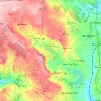
Name: Topografische Karte Ashover CP, Höhe, Relief.
Durchschnittliche Höhe: 210 m
Minimale Höhe: 91 m
Maximale Höhe: 334 m
Spenden
Rüste dich für dein nächstes Abenteuer:
Als Amazon-Partner verdient diese Seite an qualifizierten Käufen, ohne dass Ihnen zusätzliche Kosten entstehen.
Andere topografische Karten
Klicken Sie auf eine Karte, um ihre Topografie, ihre Höhe und ihr Relief anzuzeigen.
Lightwood
United Kingdom > England > Derbyshire > North East Derbyshire > Eckington
Durchschnittliche Höhe: 168 m
Sutton Scarsdale
United Kingdom > England > Derbyshire > North East Derbyshire
Durchschnittliche Höhe: 109 m
Spenden
Rüste dich für dein nächstes Abenteuer:
Als Amazon-Partner verdient diese Seite an qualifizierten Käufen, ohne dass Ihnen zusätzliche Kosten entstehen.
Ogston Reservoir
United Kingdom > England > Derbyshire > North East Derbyshire > Woolley Moor
Durchschnittliche Höhe: 137 m
Ashover Hay
United Kingdom > England > Derbyshire > North East Derbyshire
Durchschnittliche Höhe: 198 m
Spenden
Rüste dich für dein nächstes Abenteuer:
Als Amazon-Partner verdient diese Seite an qualifizierten Käufen, ohne dass Ihnen zusätzliche Kosten entstehen.
Doghole Wood
United Kingdom > England > Derbyshire > North East Derbyshire > Holymoorside
Durchschnittliche Höhe: 142 m
Middle Handley
United Kingdom > England > Derbyshire > North East Derbyshire
Durchschnittliche Höhe: 137 m
Stonebroom
United Kingdom > England > Derbyshire > North East Derbyshire
Durchschnittliche Höhe: 127 m
Spenden
Rüste dich für dein nächstes Abenteuer:
Als Amazon-Partner verdient diese Seite an qualifizierten Käufen, ohne dass Ihnen zusätzliche Kosten entstehen.
Williamthorpe
United Kingdom > England > Derbyshire > North East Derbyshire
Durchschnittliche Höhe: 139 m
Dronfield Nature Park
United Kingdom > England > Derbyshire > North East Derbyshire > Dronfield > Unstone Green
Durchschnittliche Höhe: 156 m
Marsh Lane
United Kingdom > England > Derbyshire > North East Derbyshire
Durchschnittliche Höhe: 136 m
Spenden
Rüste dich für dein nächstes Abenteuer:
Als Amazon-Partner verdient diese Seite an qualifizierten Käufen, ohne dass Ihnen zusätzliche Kosten entstehen.
Apperknowle
United Kingdom > England > Derbyshire > North East Derbyshire
Durchschnittliche Höhe: 158 m
Holestone Moor
United Kingdom > England > Derbyshire > North East Derbyshire > Ashover CP
Durchschnittliche Höhe: 231 m
Norwood Cottage Lakes
United Kingdom > England > Derbyshire > North East Derbyshire > Killamarsh
Durchschnittliche Höhe: 93 m
Spenden
Rüste dich für dein nächstes Abenteuer:
Als Amazon-Partner verdient diese Seite an qualifizierten Käufen, ohne dass Ihnen zusätzliche Kosten entstehen.
Highlane
United Kingdom > England > Derbyshire > North East Derbyshire > Eckington > Ridgeway
Durchschnittliche Höhe: 130 m
Grassmoor Country Park
United Kingdom > England > Derbyshire > North East Derbyshire > Corbriggs
Durchschnittliche Höhe: 116 m
Spenden
Rüste dich für dein nächstes Abenteuer:
Als Amazon-Partner verdient diese Seite an qualifizierten Käufen, ohne dass Ihnen zusätzliche Kosten entstehen.
Holymoorside
United Kingdom > England > Derbyshire > North East Derbyshire
Durchschnittliche Höhe: 199 m
Unstone Green
United Kingdom > England > Derbyshire > North East Derbyshire
Durchschnittliche Höhe: 137 m
Millthorpe
United Kingdom > England > Derbyshire > North East Derbyshire > Holmesfield > Millthorpe
Durchschnittliche Höhe: 211 m
Spenden
Rüste dich für dein nächstes Abenteuer:
Als Amazon-Partner verdient diese Seite an qualifizierten Käufen, ohne dass Ihnen zusätzliche Kosten entstehen.
Troway
United Kingdom > England > Derbyshire > North East Derbyshire > Eckington > Troway
Durchschnittliche Höhe: 157 m
Cartledge
United Kingdom > England > Derbyshire > North East Derbyshire > Holmesfield > Cartledge
Durchschnittliche Höhe: 192 m
Spenden
Rüste dich für dein nächstes Abenteuer:
Als Amazon-Partner verdient diese Seite an qualifizierten Käufen, ohne dass Ihnen zusätzliche Kosten entstehen.