
Spenden
Rüste dich für dein nächstes Abenteuer:
Als Amazon-Partner verdient diese Seite an qualifizierten Käufen, ohne dass Ihnen zusätzliche Kosten entstehen.
Topografische Karte McCall
Klicken Sie auf die Karte, um die Höhe anzuzeigen.
Spenden
Rüste dich für dein nächstes Abenteuer:
Als Amazon-Partner verdient diese Seite an qualifizierten Käufen, ohne dass Ihnen zusätzliche Kosten entstehen.
McCall
Brundage Mountain, northwest of McCall, opened in November 1961. Brundage has a summit elevation of 7,803 feet (2,380 m) above sea level, and a vertical drop of 1,921 feet (590 m). The slopes on Brundage Mountain are primarily west-facing and the mountain's average snowfall exceeds 320 inches (810 cm). It currently has five chairlifts and one Magic Carpet (two high-speed quad chairs, three triple chairs, and one magic carpet) with a capacity of 9,000 people per hour. The lifts afford access to 1920 acres of terrain, including 420 acres of lift-accessed, un-patrolled, without avalanche mitigation, backcountry terrain. The resort also operates a backcountry snowcat skiing operation which provides guided access to 18,000 acres (73 km2) of untracked powder in the Payette National Forest north of the ski area. There are also three terrain parks of varying difficulty. Summer activities include lift-served mountain biking trails, scenic chairlift rides, summer concerts, yoga and other calendared events. Brundage was owned by the DeBoer family, descendants of early McCall pioneers, with J. R. Simplot. In April 2016, the DeBoers took full control of the property, purchasing the 50% interest of the his family. In 2020, ownership was transferred to Brundage Mountain Holdings with the DeBoer family maintaining an ownership stake.
Spenden
Rüste dich für dein nächstes Abenteuer:
Als Amazon-Partner verdient diese Seite an qualifizierten Käufen, ohne dass Ihnen zusätzliche Kosten entstehen.
Über diese Karte
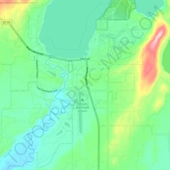
Name: Topografische Karte McCall, Höhe, Relief.
Ort: McCall, Valley County, Idaho, 83638, United States (44.86605 -116.16411 44.93408 -116.06501)
Durchschnittliche Höhe: 1’546 m
Minimale Höhe: 1’491 m
Maximale Höhe: 1’703 m
Spenden
Rüste dich für dein nächstes Abenteuer:
Als Amazon-Partner verdient diese Seite an qualifizierten Käufen, ohne dass Ihnen zusätzliche Kosten entstehen.
Andere topografische Karten
Klicken Sie auf eine Karte, um ihre Topografie, ihre Höhe und ihr Relief anzuzeigen.
Spenden
Rüste dich für dein nächstes Abenteuer:
Als Amazon-Partner verdient diese Seite an qualifizierten Käufen, ohne dass Ihnen zusätzliche Kosten entstehen.
Spenden
Rüste dich für dein nächstes Abenteuer:
Als Amazon-Partner verdient diese Seite an qualifizierten Käufen, ohne dass Ihnen zusätzliche Kosten entstehen.