
Spenden
Rüste dich für dein nächstes Abenteuer:
Als Amazon-Partner verdient diese Seite an qualifizierten Käufen, ohne dass Ihnen zusätzliche Kosten entstehen.
Topografische Karte Chief
Klicken Sie auf die Karte, um die Höhe anzuzeigen.
Spenden
Rüste dich für dein nächstes Abenteuer:
Als Amazon-Partner verdient diese Seite an qualifizierten Käufen, ohne dass Ihnen zusätzliche Kosten entstehen.
Über diese Karte
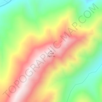
Name: Topografische Karte Chief, Höhe, Relief.
Ort: Chief, Valley County, Idaho, United States (44.82474 -115.28214 44.82484 -115.28204)
Durchschnittliche Höhe: 2’249 m
Minimale Höhe: 1’872 m
Maximale Höhe: 2’625 m
Spenden
Rüste dich für dein nächstes Abenteuer:
Als Amazon-Partner verdient diese Seite an qualifizierten Käufen, ohne dass Ihnen zusätzliche Kosten entstehen.
Andere topografische Karten
Klicken Sie auf eine Karte, um ihre Topografie, ihre Höhe und ihr Relief anzuzeigen.
McCall
United States > Idaho > Valley County
McCall is located at 44°54′39″N 116°6′11″W / 44.91083°N 116.10306°W / 44.91083; -116.10306 (44.910906, -116.103087), at an elevation of 5,013 feet (1,528 m) above sea level.
Durchschnittliche Höhe: 1’546 m
Donnelly
United States > Idaho > Valley County
Donnelly is located at 44°43′49″N 116°4′37″W / 44.73028°N 116.07694°W / 44.73028; -116.07694, at an elevation of 4,865 feet (1,483 m) above sea level. According to the United States Census Bureau, the city has a total area of 0.45 square miles (1.17 km2), all of it land.
Durchschnittliche Höhe: 1’483 m
McCall
United States > Idaho > Valley County
McCall is located at 44°54′39″N 116°6′11″W / 44.91083°N 116.10306°W / 44.91083; -116.10306 (44.910906, -116.103087),[7] at an elevation of 5,013 feet (1,528 m) above sea level.
Durchschnittliche Höhe: 1’546 m
Spenden
Rüste dich für dein nächstes Abenteuer:
Als Amazon-Partner verdient diese Seite an qualifizierten Käufen, ohne dass Ihnen zusätzliche Kosten entstehen.
Spenden
Rüste dich für dein nächstes Abenteuer:
Als Amazon-Partner verdient diese Seite an qualifizierten Käufen, ohne dass Ihnen zusätzliche Kosten entstehen.
McCall
United States > Idaho > Valley County
Brundage Mountain, northwest of McCall, opened in November 1961. Brundage has a summit elevation of 7,803 feet (2,380 m) above sea level, and a vertical drop of 1,921 feet (590 m). The slopes on Brundage Mountain are primarily west-facing and the mountain's average snowfall exceeds 320 inches (810 cm). It…
Durchschnittliche Höhe: 1’546 m