
Topografische Karte Fort Kent
Interaktive Karte
Klicken Sie auf die Karte, um die Höhe anzuzeigen.
Über diese Karte
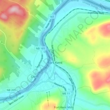
Name: Topografische Karte Fort Kent, Höhe, Relief.
Ort: Fort Kent, Aroostook County, Maine, United States (47.23774 -68.61080 47.28634 -68.56132)
Durchschnittliche Höhe: 217 m
Minimale Höhe: 148 m
Maximale Höhe: 367 m
Andere topografische Karten
Klicken Sie auf eine Karte, um ihre Topografie, ihre Höhe und ihr Relief anzuzeigen.
Fort Kent Mills
United States > Maine > Aroostook County > Fort Kent
Fort Kent Mills, Fort Kent, Aroostook County, Maine, 04743, United States
Durchschnittliche Höhe: 213 m
Saint John River
United States > Maine > Aroostook County > Fort Kent
Saint John River, Fort Kent, Aroostook County, Maine, United States
Durchschnittliche Höhe: 208 m