
Topografische Karte Saint John River
Interaktive Karte
Klicken Sie auf die Karte, um die Höhe anzuzeigen.
Über diese Karte
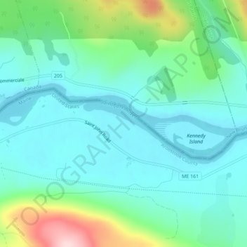
Name: Topografische Karte Saint John River, Höhe, Relief.
Durchschnittliche Höhe: 208 m
Minimale Höhe: 147 m
Maximale Höhe: 409 m
When the Europeans arrived into Wolastokuk, the homeland of the Maliseet Nation and Saint John River basin, they found the locals hunting, gathering, and farming near the banks of the river. European colonists may have used fields and town sites prepared by the natives. Archaeological evidence is that the Maliseet had economic and cultural ties with large portions of North America from their country's homebase within the Wabanaki Confederacy of Dawnland. The Maliseet dealt with freshets by having their village above the floodplain, for example Meductic, while cultivating at a lower elevation where the fields were fertilized by the floodwaters. The Maliseet were highly mobile and the Saint John River was a primary means of transportation.
Andere topografische Karten
Klicken Sie auf eine Karte, um ihre Topografie, ihre Höhe und ihr Relief anzuzeigen.
Fort Kent Mills
United States > Maine > Aroostook County > Fort Kent
Fort Kent Mills, Fort Kent, Aroostook County, Maine, 04743, United States
Durchschnittliche Höhe: 213 m
Fort Kent
United States > Maine > Aroostook County > Fort Kent
Fort Kent, Aroostook County, Maine, United States
Durchschnittliche Höhe: 217 m