
Spenden
Rüste dich für dein nächstes Abenteuer:
Als Amazon-Partner verdient diese Seite an qualifizierten Käufen, ohne dass Ihnen zusätzliche Kosten entstehen.
Topografische Karte Bishop's Stortford
Klicken Sie auf die Karte, um die Höhe anzuzeigen.
Spenden
Rüste dich für dein nächstes Abenteuer:
Als Amazon-Partner verdient diese Seite an qualifizierten Käufen, ohne dass Ihnen zusätzliche Kosten entstehen.
Bishop's Stortford
Stortford, along with the rest of Britain, has a temperate maritime climate, with cool summers and mild winters. The nearest weather station for which averages and extremes are available is Stansted Airport, about 2+1⁄2 miles (4 kilometres) due east of Stortford's town centre. Located at an elevation of over 100 m, the weather station, and parts of Stortford in general are marginally cooler throughout the year than the Cambridgeshire area to the north or the London area to the south. Nonetheless, Stortford is still warmer than the English average.
Spenden
Rüste dich für dein nächstes Abenteuer:
Als Amazon-Partner verdient diese Seite an qualifizierten Käufen, ohne dass Ihnen zusätzliche Kosten entstehen.
Über diese Karte
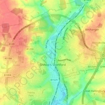
Name: Topografische Karte Bishop's Stortford, Höhe, Relief.
Durchschnittliche Höhe: 83 m
Minimale Höhe: 52 m
Maximale Höhe: 111 m
Spenden
Rüste dich für dein nächstes Abenteuer:
Als Amazon-Partner verdient diese Seite an qualifizierten Käufen, ohne dass Ihnen zusätzliche Kosten entstehen.
Andere topografische Karten
Klicken Sie auf eine Karte, um ihre Topografie, ihre Höhe und ihr Relief anzuzeigen.
Spellbrook
United Kingdom > England > Hertfordshire > East Hertfordshire > Sawbridgeworth
Durchschnittliche Höhe: 71 m
Little Amwell
United Kingdom > England > Hertfordshire > East Hertfordshire
Durchschnittliche Höhe: 65 m
Broken Green
United Kingdom > England > Hertfordshire > East Hertfordshire
Durchschnittliche Höhe: 97 m
Hertingfordbury
United Kingdom > England > Hertfordshire > East Hertfordshire
Durchschnittliche Höhe: 61 m
Spenden
Rüste dich für dein nächstes Abenteuer:
Als Amazon-Partner verdient diese Seite an qualifizierten Käufen, ohne dass Ihnen zusätzliche Kosten entstehen.
Astonbury Wood
United Kingdom > England > Hertfordshire > East Hertfordshire > Aston
Durchschnittliche Höhe: 83 m
Perry Green
United Kingdom > England > Hertfordshire > East Hertfordshire
Durchschnittliche Höhe: 78 m
Waterford
United Kingdom > England > Hertfordshire > East Hertfordshire > Waterford
Durchschnittliche Höhe: 66 m
Throcking
United Kingdom > England > Hertfordshire > East Hertfordshire > Buntingford
Durchschnittliche Höhe: 126 m
Spenden
Rüste dich für dein nächstes Abenteuer:
Als Amazon-Partner verdient diese Seite an qualifizierten Käufen, ohne dass Ihnen zusätzliche Kosten entstehen.
Tewin Wood
United Kingdom > England > Hertfordshire > East Hertfordshire > Burnham Green
Durchschnittliche Höhe: 101 m
Spenden
Rüste dich für dein nächstes Abenteuer:
Als Amazon-Partner verdient diese Seite an qualifizierten Käufen, ohne dass Ihnen zusätzliche Kosten entstehen.
Chapmore End
United Kingdom > England > Hertfordshire > East Hertfordshire > Tonwell
Durchschnittliche Höhe: 65 m
Burnham Green
United Kingdom > England > Hertfordshire > East Hertfordshire
Durchschnittliche Höhe: 102 m
Stanstead St Margarets
United Kingdom > England > Hertfordshire > East Hertfordshire
Durchschnittliche Höhe: 48 m
Hadham Cross
United Kingdom > England > Hertfordshire > East Hertfordshire > Much Hadham
Durchschnittliche Höhe: 79 m
Spenden
Rüste dich für dein nächstes Abenteuer:
Als Amazon-Partner verdient diese Seite an qualifizierten Käufen, ohne dass Ihnen zusätzliche Kosten entstehen.
Thorley Street
United Kingdom > England > Hertfordshire > East Hertfordshire > Thorley
Durchschnittliche Höhe: 74 m
Whempstead
United Kingdom > England > Hertfordshire > East Hertfordshire > Dane End
Durchschnittliche Höhe: 95 m
Spenden
Rüste dich für dein nächstes Abenteuer:
Als Amazon-Partner verdient diese Seite an qualifizierten Käufen, ohne dass Ihnen zusätzliche Kosten entstehen.
Church End
United Kingdom > England > Hertfordshire > East Hertfordshire > Little Hadham
Durchschnittliche Höhe: 95 m
Crab's Green
United Kingdom > England > Hertfordshire > East Hertfordshire > Stocking Pelham
Durchschnittliche Höhe: 111 m
Spenden
Rüste dich für dein nächstes Abenteuer:
Als Amazon-Partner verdient diese Seite an qualifizierten Käufen, ohne dass Ihnen zusätzliche Kosten entstehen.
Watton-at-Stone
United Kingdom > England > Hertfordshire > East Hertfordshire
Durchschnittliche Höhe: 86 m
Cold Christmas
United Kingdom > England > Hertfordshire > East Hertfordshire
Durchschnittliche Höhe: 72 m
Letty Green
United Kingdom > England > Hertfordshire > East Hertfordshire
Durchschnittliche Höhe: 69 m
Baker's End
United Kingdom > England > Hertfordshire > East Hertfordshire > Wareside > Baker's End
Durchschnittliche Höhe: 73 m
Spenden
Rüste dich für dein nächstes Abenteuer:
Als Amazon-Partner verdient diese Seite an qualifizierten Käufen, ohne dass Ihnen zusätzliche Kosten entstehen.
Hare Street
United Kingdom > England > Hertfordshire > East Hertfordshire > Great Hormead
Durchschnittliche Höhe: 110 m
Hertford Heath Nature Reserve
United Kingdom > England > Hertfordshire > East Hertfordshire > Hertford Heath
Durchschnittliche Höhe: 79 m
Painter's Green
United Kingdom > England > Hertfordshire > East Hertfordshire > Datchworth
Durchschnittliche Höhe: 100 m
Dassels
United Kingdom > England > Hertfordshire > East Hertfordshire > Dassels
Durchschnittliche Höhe: 104 m
Spenden
Rüste dich für dein nächstes Abenteuer:
Als Amazon-Partner verdient diese Seite an qualifizierten Käufen, ohne dass Ihnen zusätzliche Kosten entstehen.
Moor Green
United Kingdom > England > Hertfordshire > East Hertfordshire > Ardeley
Durchschnittliche Höhe: 123 m
Broad Green
United Kingdom > England > Hertfordshire > East Hertfordshire > Bayford
Durchschnittliche Höhe: 73 m
Tewin Wood
United Kingdom > England > Hertfordshire > East Hertfordshire > Burnham Green
Durchschnittliche Höhe: 101 m
Levens Green
United Kingdom > England > Hertfordshire > East Hertfordshire
Durchschnittliche Höhe: 111 m
Spenden
Rüste dich für dein nächstes Abenteuer:
Als Amazon-Partner verdient diese Seite an qualifizierten Käufen, ohne dass Ihnen zusätzliche Kosten entstehen.
Hertford Lock No 1
United Kingdom > England > Hertfordshire > East Hertfordshire > Hertford
Durchschnittliche Höhe: 53 m
Cold Christmas
United Kingdom > England > Hertfordshire > East Hertfordshire
Durchschnittliche Höhe: 72 m