
Topografische Karte Letty Green
Klicken Sie auf die Karte, um die Höhe anzuzeigen.
Über diese Karte
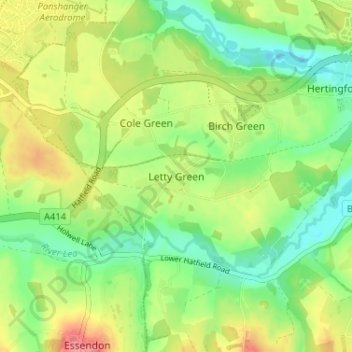
Name: Topografische Karte Letty Green, Höhe, Relief.
Durchschnittliche Höhe: 69 m
Minimale Höhe: 38 m
Maximale Höhe: 109 m
Andere topografische Karten
Klicken Sie auf eine Karte, um ihre Topografie, ihre Höhe und ihr Relief anzuzeigen.
Thorley
United Kingdom > England > Hertfordshire > East Hertfordshire > Thorley
Durchschnittliche Höhe: 82 m
River Stort
United Kingdom > England > Hertfordshire > East Hertfordshire
Durchschnittliche Höhe: 90 m
Astonbury Wood
United Kingdom > England > Hertfordshire > East Hertfordshire > Aston
Durchschnittliche Höhe: 83 m
Sawbridgeworth
United Kingdom > England > Hertfordshire > East Hertfordshire > Sawbridgeworth
Durchschnittliche Höhe: 67 m
Standon
United Kingdom > England > Hertfordshire > East Hertfordshire > Standon
Durchschnittliche Höhe: 97 m
Bishop's Stortford
United Kingdom > England > Hertfordshire > East Hertfordshire > Thorley
Stortford, along with the rest of Britain, has a temperate maritime climate, with cool summers and mild winters. The nearest weather station for which averages and extremes are available is Stansted Airport, about 2+1⁄2 miles (4 kilometres) due east of Stortford's town centre. Located at an elevation of over…
Durchschnittliche Höhe: 83 m
Aston
United Kingdom > England > Hertfordshire > East Hertfordshire > Aston
Durchschnittliche Höhe: 99 m
King's Meads
United Kingdom > England > Hertfordshire > East Hertfordshire > Ware
Durchschnittliche Höhe: 53 m
Furneux Pelham
United Kingdom > England > Hertfordshire > East Hertfordshire > Furneux Pelham
Durchschnittliche Höhe: 113 m
Thundridge
United Kingdom > England > Hertfordshire > East Hertfordshire > High Cross
Durchschnittliche Höhe: 78 m
Little Hadham
United Kingdom > England > Hertfordshire > East Hertfordshire
Durchschnittliche Höhe: 91 m
Stocking Pelham
United Kingdom > England > Hertfordshire > East Hertfordshire > Stocking Pelham
Durchschnittliche Höhe: 114 m
Little Berkhamsted
United Kingdom > England > Hertfordshire > East Hertfordshire
Durchschnittliche Höhe: 88 m
Datchworth
United Kingdom > England > Hertfordshire > East Hertfordshire > Datchworth
Durchschnittliche Höhe: 102 m
Much Hadham
United Kingdom > England > Hertfordshire > East Hertfordshire
Durchschnittliche Höhe: 80 m
Buntingford
United Kingdom > England > Hertfordshire > East Hertfordshire > Buntingford
Durchschnittliche Höhe: 110 m
Widford
United Kingdom > England > Hertfordshire > East Hertfordshire > Widford
Durchschnittliche Höhe: 73 m
Tewin
United Kingdom > England > Hertfordshire > East Hertfordshire > Tewin
Durchschnittliche Höhe: 91 m
Hertford Heath Nature Reserve
United Kingdom > England > Hertfordshire > East Hertfordshire > Hertford Heath
Durchschnittliche Höhe: 79 m
Hertingfordbury
United Kingdom > England > Hertfordshire > East Hertfordshire
Durchschnittliche Höhe: 68 m
Stocking Pelham
United Kingdom > England > Hertfordshire > East Hertfordshire
Durchschnittliche Höhe: 114 m
Buntingford
United Kingdom > England > Hertfordshire > East Hertfordshire > Buntingford
Durchschnittliche Höhe: 110 m
Hertford Heath
United Kingdom > England > Hertfordshire > East Hertfordshire
Durchschnittliche Höhe: 74 m
Hertford Lock No 1
United Kingdom > England > Hertfordshire > East Hertfordshire > Hertford
Durchschnittliche Höhe: 53 m
Braughing
United Kingdom > England > Hertfordshire > East Hertfordshire > Braughing
Durchschnittliche Höhe: 104 m
Sawbridgeworth
United Kingdom > England > Hertfordshire > East Hertfordshire > Sawbridgeworth
Durchschnittliche Höhe: 67 m