
Spenden
Rüste dich für dein nächstes Abenteuer:
Als Amazon-Partner verdient diese Seite an qualifizierten Käufen, ohne dass Ihnen zusätzliche Kosten entstehen.
Topografische Karte Clark Fork
Klicken Sie auf die Karte, um die Höhe anzuzeigen.
Spenden
Rüste dich für dein nächstes Abenteuer:
Als Amazon-Partner verdient diese Seite an qualifizierten Käufen, ohne dass Ihnen zusätzliche Kosten entstehen.
Clark Fork
Clark Fork is located at 48°8′50″N 116°10′42″W / 48.14722°N 116.17833°W / 48.14722; -116.17833 (48.147180, -116.178270), at an elevation of 2,090 feet (637 m) above sea level. The town is situated on the Clark Fork River, on the eastern shores of Lake Pend Oreille. in the northern panhandle of the state. According to the United States Census Bureau, the city has a total area of 0.92 square miles (2.38 km2), all of it land. The Lightning Creek passes just north and west of the town.
Spenden
Rüste dich für dein nächstes Abenteuer:
Als Amazon-Partner verdient diese Seite an qualifizierten Käufen, ohne dass Ihnen zusätzliche Kosten entstehen.
Über diese Karte
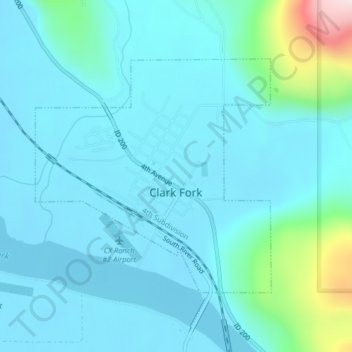
Name: Topografische Karte Clark Fork, Höhe, Relief.
Ort: Clark Fork, Bonner County, Idaho, 83811, United States (48.13748 -116.19191 48.15545 -116.16474)
Durchschnittliche Höhe: 681 m
Minimale Höhe: 625 m
Maximale Höhe: 1’040 m
Spenden
Rüste dich für dein nächstes Abenteuer:
Als Amazon-Partner verdient diese Seite an qualifizierten Käufen, ohne dass Ihnen zusätzliche Kosten entstehen.
Andere topografische Karten
Klicken Sie auf eine Karte, um ihre Topografie, ihre Höhe und ihr Relief anzuzeigen.
Spenden
Rüste dich für dein nächstes Abenteuer:
Als Amazon-Partner verdient diese Seite an qualifizierten Käufen, ohne dass Ihnen zusätzliche Kosten entstehen.
Spenden
Rüste dich für dein nächstes Abenteuer:
Als Amazon-Partner verdient diese Seite an qualifizierten Käufen, ohne dass Ihnen zusätzliche Kosten entstehen.