
Spenden
Rüste dich für dein nächstes Abenteuer:
Als Amazon-Partner verdient diese Seite an qualifizierten Käufen, ohne dass Ihnen zusätzliche Kosten entstehen.
Topografische Karte Vay
Klicken Sie auf die Karte, um die Höhe anzuzeigen.
Spenden
Rüste dich für dein nächstes Abenteuer:
Als Amazon-Partner verdient diese Seite an qualifizierten Käufen, ohne dass Ihnen zusätzliche Kosten entstehen.
Über diese Karte
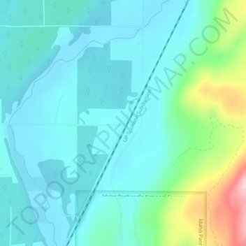
Name: Topografische Karte Vay, Höhe, Relief.
Ort: Vay, Bonner County, Idaho, United States (48.10546 -116.78797 48.12546 -116.76797)
Durchschnittliche Höhe: 698 m
Minimale Höhe: 649 m
Maximale Höhe: 895 m
Spenden
Rüste dich für dein nächstes Abenteuer:
Als Amazon-Partner verdient diese Seite an qualifizierten Käufen, ohne dass Ihnen zusätzliche Kosten entstehen.
Andere topografische Karten
Klicken Sie auf eine Karte, um ihre Topografie, ihre Höhe und ihr Relief anzuzeigen.
Hope
United States > Idaho > Bonner County
Hope is located at 48°14′55″N 116°18′33″W / 48.24861°N 116.30917°W / 48.24861; -116.30917 (48.248728, -116.309214), at an elevation of 2,192 feet (668 m) above sea level. The city sits on the northeast shore of Lake Pend Oreille.
Durchschnittliche Höhe: 763 m
Ponderay
United States > Idaho > Bonner County
Ponderay is located at 48°18′11″N 116°32′18″W / 48.30306°N 116.53833°W / 48.30306; -116.53833 (48.303080, -116.538292), at an elevation of 2,126 feet (648 m) above sea level. According to the United States Census Bureau, the city has a total area of 3.02 square miles (7.82 km2), of which,…
Durchschnittliche Höhe: 652 m
Priest River
United States > Idaho > Bonner County
Priest River is located at 48°11′0″N 116°54′34″W / 48.18333°N 116.90944°W / 48.18333; -116.90944 (48.183388, -116.909555), at an elevation of 2,139 feet (652 m) above sea level.
Durchschnittliche Höhe: 742 m
Spenden
Rüste dich für dein nächstes Abenteuer:
Als Amazon-Partner verdient diese Seite an qualifizierten Käufen, ohne dass Ihnen zusätzliche Kosten entstehen.
Oldtown
United States > Idaho > Bonner County
Oldtown is located at 48°11′8″N 117°1′49″W / 48.18556°N 117.03028°W / 48.18556; -117.03028 (48.185623, -117.030158), at an elevation of 2,134 feet (650 meters).
Durchschnittliche Höhe: 682 m
Priest River
United States > Idaho > Bonner County
Priest River is located at 48°11′0″N 116°54′34″W / 48.18333°N 116.90944°W / 48.18333; -116.90944 (48.183388, -116.909555), at an elevation of 2,139 feet (652 m) above sea level.
Durchschnittliche Höhe: 742 m
Spenden
Rüste dich für dein nächstes Abenteuer:
Als Amazon-Partner verdient diese Seite an qualifizierten Käufen, ohne dass Ihnen zusätzliche Kosten entstehen.
Clark Fork
United States > Idaho > Bonner County
Clark Fork is located at 48°8′50″N 116°10′42″W / 48.14722°N 116.17833°W / 48.14722; -116.17833 (48.147180, -116.178270), at an elevation of 2,090 feet (637 m) above sea level. The town is situated on the Clark Fork River, on the eastern shores of Lake Pend Oreille. in the northern…
Durchschnittliche Höhe: 681 m