
Spenden
Rüste dich für dein nächstes Abenteuer:
Als Amazon-Partner verdient diese Seite an qualifizierten Käufen, ohne dass Ihnen zusätzliche Kosten entstehen.
Topografische Karte Minicoy
Klicken Sie auf die Karte, um die Höhe anzuzeigen.
Spenden
Rüste dich für dein nächstes Abenteuer:
Als Amazon-Partner verdient diese Seite an qualifizierten Käufen, ohne dass Ihnen zusätzliche Kosten entstehen.
Über diese Karte
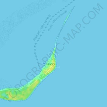
Name: Topografische Karte Minicoy, Höhe, Relief.
Ort: Minicoy, Lakshadweep, 682559, India (8.26566 73.01070 8.32507 73.07848)
Durchschnittliche Höhe: 1 m
Minimale Höhe: -1 m
Maximale Höhe: 17 m
Spenden
Rüste dich für dein nächstes Abenteuer:
Als Amazon-Partner verdient diese Seite an qualifizierten Käufen, ohne dass Ihnen zusätzliche Kosten entstehen.
Andere topografische Karten
Klicken Sie auf eine Karte, um ihre Topografie, ihre Höhe und ihr Relief anzuzeigen.
Kavaratti
India > Lakshadweep > Kavaratti
The island of Kavaratti lies 360 km (190 nmi) off the coast of the state of Kerala at 10°34′N 72°38′E / 10.57°N 72.64°E / 10.57; 72.64. It has an average elevation of 0 metres (0 feet).
Durchschnittliche Höhe: 0 m
Kavaratti Island
India > Lakshadweep > Kavaratti > Kavaratti
The island of Kavaratti lies 360 km (190 nmi) off the coast of the state of Kerala at 10°34′N 72°38′E / 10.57°N 72.64°E / 10.57; 72.64. It has an average elevation of 0 metres (0 feet).
Durchschnittliche Höhe: 2 m
Kavaratti
India > Lakshadweep > Kavaratti
The atoll of Kavaratti lies 360 km (220 mi) off the Malabar coast of mainland India. The island is 5.6 km (3.5 mi) long, and 1.6 km (0.99 mi) wide, and occupies an area of 4.22 km2 (1.63 sq mi). It is surrounded by a 6 km (3.7 mi) long lagoon with an area of 4.96 km2 (1.92 sq mi). It is located to the east of…
Durchschnittliche Höhe: 0 m
Spenden
Rüste dich für dein nächstes Abenteuer:
Als Amazon-Partner verdient diese Seite an qualifizierten Käufen, ohne dass Ihnen zusätzliche Kosten entstehen.