
Topografische Karte Epworth
Interaktive Karte
Klicken Sie auf die Karte, um die Höhe anzuzeigen.
Über diese Karte
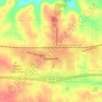
Name: Topografische Karte Epworth, Höhe, Relief.
Ort: Epworth, Dubuque County, Iowa, 52045, United States (42.43881 -90.94657 42.45523 -90.91244)
Durchschnittliche Höhe: 310 m
Minimale Höhe: 264 m
Maximale Höhe: 333 m
Andere topografische Karten
Klicken Sie auf eine Karte, um ihre Topografie, ihre Höhe und ihr Relief anzuzeigen.
Dubuque
United States > Iowa > Dubuque County
Dubuque, Dubuque County, Iowa, United States
Durchschnittliche Höhe: 241 m
Mississippi River
United States > Iowa > Dubuque County > Dubuque > Eagle Point
Mississippi River, Eagle Point, Dubuque, Dubuque County, Iowa, 52001, United States
Durchschnittliche Höhe: 200 m
Mines of Spain State Recreation Area
United States > Iowa > Dubuque County > Dubuque
Mines of Spain State Recreation Area, Dubuque, Dubuque County, Iowa, United States
Durchschnittliche Höhe: 217 m
Holy Cross
United States > Iowa > Dubuque County
Holy Cross, Dubuque County, Iowa, United States
Durchschnittliche Höhe: 355 m
Farley
United States > Iowa > Dubuque County
Farley, Dubuque County, Iowa, 52046, United States
Durchschnittliche Höhe: 335 m
Dubuque County
United States > Iowa > Dubuque County
Dubuque County, Iowa, United States
Durchschnittliche Höhe: 284 m