
Topografische Karte Dubuque County
Interaktive Karte
Klicken Sie auf die Karte, um die Höhe anzuzeigen.
Über diese Karte
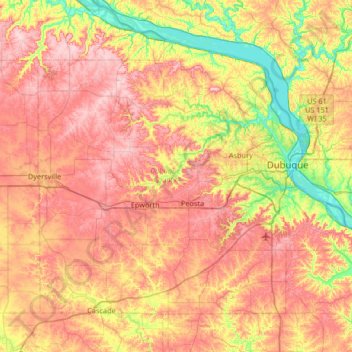
Name: Topografische Karte Dubuque County, Höhe, Relief.
Ort: Dubuque County, Iowa, United States (42.29334 -91.13344 42.67462 -90.47332)
Durchschnittliche Höhe: 284 m
Minimale Höhe: 180 m
Maximale Höhe: 381 m
The county seat is Dubuque, Iowa, which is located along the Mississippi River in the east-central portion of the county. Eastern Dubuque County is markedly different from the western portion in that its topography is very uneven. The city of Dubuque and surrounding areas adjacent to the Mississippi River have many steep hills, bluffs, and ravines. Also, the eastern portion is more heavily wooded than the west, which is mostly rolling farmland.
Andere topografische Karten
Klicken Sie auf eine Karte, um ihre Topografie, ihre Höhe und ihr Relief anzuzeigen.
Dubuque
United States > Iowa > Dubuque County
Dubuque, Dubuque County, Iowa, United States
Durchschnittliche Höhe: 241 m
Mississippi River
United States > Iowa > Dubuque County > Dubuque > Eagle Point
Mississippi River, Eagle Point, Dubuque, Dubuque County, Iowa, 52001, United States
Durchschnittliche Höhe: 200 m
Mines of Spain State Recreation Area
United States > Iowa > Dubuque County > Dubuque
Mines of Spain State Recreation Area, Dubuque, Dubuque County, Iowa, United States
Durchschnittliche Höhe: 217 m
Holy Cross
United States > Iowa > Dubuque County
Holy Cross, Dubuque County, Iowa, United States
Durchschnittliche Höhe: 355 m
Farley
United States > Iowa > Dubuque County
Farley, Dubuque County, Iowa, 52046, United States
Durchschnittliche Höhe: 335 m
Epworth
United States > Iowa > Dubuque County
Epworth, Dubuque County, Iowa, 52045, United States
Durchschnittliche Höhe: 310 m