
Topografische Karte Millsfield
Interaktive Karte
Klicken Sie auf die Karte, um die Höhe anzuzeigen.
Über diese Karte
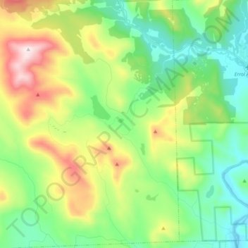
Name: Topografische Karte Millsfield, Höhe, Relief.
Ort: Millsfield, Coös County, New Hampshire, United States (44.70504 -71.33002 44.82483 -71.21107)
Durchschnittliche Höhe: 583 m
Minimale Höhe: 358 m
Maximale Höhe: 1’051 m
Andere topografische Karten
Klicken Sie auf eine Karte, um ihre Topografie, ihre Höhe und ihr Relief anzuzeigen.
Mount Washington
United States > New Hampshire > Coos County
Mount Washington, Coös County, New Hampshire, United States
Durchschnittliche Höhe: 1’568 m
Jefferson Highland
United States > New Hampshire > Coos County > Jefferson
Jefferson Highland, Jefferson, Coös County, New Hampshire, 03583, United States
Durchschnittliche Höhe: 451 m
Jefferson
United States > New Hampshire > Coos County
Jefferson, Coös County, New Hampshire, 03583, United States
Durchschnittliche Höhe: 493 m
Blake Islands
United States > New Hampshire > Coos County > Errol
Blake Islands, Errol, Coös County, New Hampshire, United States
Durchschnittliche Höhe: 530 m
Pittsburg
United States > New Hampshire > Coos County
Pittsburg, Coös County, New Hampshire, United States
Durchschnittliche Höhe: 522 m
Dummer
United States > New Hampshire > Coos County
Dummer, Coos County, New Hampshire, United States
Durchschnittliche Höhe: 419 m
Glen House
United States > New Hampshire > Coos County
Glen House, Green's Grant, Coos County, New Hampshire, United States
Durchschnittliche Höhe: 647 m
Fabyan
United States > New Hampshire > Coos County > Carroll
Fabyan, Carroll, Coos County, New Hampshire, 03575, United States
Durchschnittliche Höhe: 590 m
Lake Francis
United States > New Hampshire > Coos County > Clarksville
Lake Francis, Clarksville, Coos County, New Hampshire, United States
Durchschnittliche Höhe: 498 m
Bretton Woods
United States > New Hampshire > Coos County > Carroll
Bretton Woods, Carroll, Coös County, New Hampshire, 03575, United States
Durchschnittliche Höhe: 577 m
Mount Pisgah
United States > New Hampshire > Coos County > Clarksville
Mount Pisgah, Clarksville, Coos County, New Hampshire, United States
Durchschnittliche Höhe: 735 m
Sugar Mountain
United States > New Hampshire > Coos County > Gorham
Sugar Mountain, Gorham, Coos County, New Hampshire, United States
Durchschnittliche Höhe: 607 m
Gorham
United States > New Hampshire > Coos County
Gorham, Coös County, New Hampshire, 03581, United States
Durchschnittliche Höhe: 477 m
Whitefield
United States > New Hampshire > Coos County
Whitefield, Coös County, New Hampshire, United States
Durchschnittliche Höhe: 365 m
Errol
United States > New Hampshire > Coos County
Errol, Coös County, New Hampshire, United States
Durchschnittliche Höhe: 453 m
Stewartstown
United States > New Hampshire > Coos County
Stewartstown, Coös County, New Hampshire, 03597, United States
Durchschnittliche Höhe: 485 m