
Topografische Karte Jefferson
Interaktive Karte
Klicken Sie auf die Karte, um die Höhe anzuzeigen.
Über diese Karte
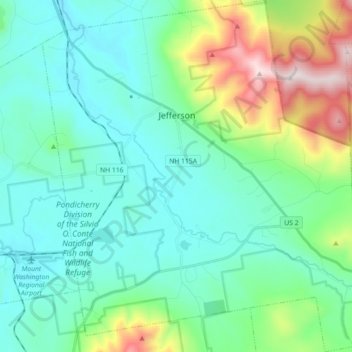
Name: Topografische Karte Jefferson, Höhe, Relief.
Ort: Jefferson, Coös County, New Hampshire, 03583, United States (44.33323 -71.54324 44.46090 -71.38018)
Durchschnittliche Höhe: 493 m
Minimale Höhe: 294 m
Maximale Höhe: 1’208 m
Jefferson is located on U.S. Route 2 between Lancaster and Randolph, west of the midpoint between the Vermont and Maine borders. Set astride the broad Israel River valley, the town commands remarkable views of the Presidential Range and other White Mountain summits. Mount Starr King, with an elevation of 3,907 feet (1,191 m) and named for Thomas Starr King, is the highest point in town, near the town's northern border. It is regularly traversed by hikers scaling nearby 4,006-foot (1,221 m) Mount Waumbek, one of the "four-thousand footers"—the 48 peaks above 4,000 feet (1,200 m) in New Hampshire. Jefferson lies fully within the Connecticut River watershed.
Andere topografische Karten
Klicken Sie auf eine Karte, um ihre Topografie, ihre Höhe und ihr Relief anzuzeigen.
Mount Washington
United States > New Hampshire > Coos County
Mount Washington, Coös County, New Hampshire, United States
Durchschnittliche Höhe: 1’568 m
Millsfield
United States > New Hampshire > Coos County
Millsfield, Coös County, New Hampshire, United States
Durchschnittliche Höhe: 583 m
Jefferson Highland
United States > New Hampshire > Coos County > Jefferson
Jefferson Highland, Jefferson, Coös County, New Hampshire, 03583, United States
Durchschnittliche Höhe: 451 m
Blake Islands
United States > New Hampshire > Coos County > Errol
Blake Islands, Errol, Coös County, New Hampshire, United States
Durchschnittliche Höhe: 530 m
Pittsburg
United States > New Hampshire > Coos County
Pittsburg, Coös County, New Hampshire, United States
Durchschnittliche Höhe: 522 m
Dummer
United States > New Hampshire > Coos County
Dummer, Coos County, New Hampshire, United States
Durchschnittliche Höhe: 419 m
Glen House
United States > New Hampshire > Coos County
Glen House, Green's Grant, Coos County, New Hampshire, United States
Durchschnittliche Höhe: 647 m
Fabyan
United States > New Hampshire > Coos County > Carroll
Fabyan, Carroll, Coos County, New Hampshire, 03575, United States
Durchschnittliche Höhe: 590 m
Lake Francis
United States > New Hampshire > Coos County > Clarksville
Lake Francis, Clarksville, Coos County, New Hampshire, United States
Durchschnittliche Höhe: 498 m
Bretton Woods
United States > New Hampshire > Coos County > Carroll
Bretton Woods, Carroll, Coös County, New Hampshire, 03575, United States
Durchschnittliche Höhe: 577 m
Mount Pisgah
United States > New Hampshire > Coos County > Clarksville
Mount Pisgah, Clarksville, Coos County, New Hampshire, United States
Durchschnittliche Höhe: 735 m
Sugar Mountain
United States > New Hampshire > Coos County > Gorham
Sugar Mountain, Gorham, Coos County, New Hampshire, United States
Durchschnittliche Höhe: 607 m
Gorham
United States > New Hampshire > Coos County
Gorham, Coös County, New Hampshire, 03581, United States
Durchschnittliche Höhe: 477 m
Whitefield
United States > New Hampshire > Coos County
Whitefield, Coös County, New Hampshire, United States
Durchschnittliche Höhe: 365 m
Errol
United States > New Hampshire > Coos County
Errol, Coös County, New Hampshire, United States
Durchschnittliche Höhe: 453 m
Stewartstown
United States > New Hampshire > Coos County
Stewartstown, Coös County, New Hampshire, 03597, United States
Durchschnittliche Höhe: 485 m