
Topografische Karte Te Hāpua Waikawa / Lake Lyndon
Interaktive Karte
Klicken Sie auf die Karte, um die Höhe anzuzeigen.
Über diese Karte
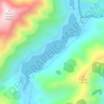
Name: Topografische Karte Te Hāpua Waikawa / Lake Lyndon, Höhe, Relief.
Durchschnittliche Höhe: 1’012 m
Minimale Höhe: 827 m
Maximale Höhe: 1’488 m
Lake Lyndon is a small lake in the Canterbury region of New Zealand's South Island. It is located near Porters Pass on State Highway 73 after Springfield heading into the Southern Alps. The lake regularly freezes in winter due to its elevation and location on the outer border of the Southern Alps.
Andere topografische Karten
Klicken Sie auf eine Karte, um ihre Topografie, ihre Höhe und ihr Relief anzuzeigen.
Springfield
New Zealand > Canterbury > Selwyn District
Springfield, Selwyn District, Canterbury, 7649, New Zealand
Durchschnittliche Höhe: 396 m
Prebbleton
New Zealand > Canterbury > Selwyn District
Prebbleton, Selwyn District, Canterbury, 7604, New Zealand
Durchschnittliche Höhe: 25 m
Windwhistle
New Zealand > Canterbury > Selwyn District
Windwhistle, Selwyn District, Canterbury, New Zealand
Durchschnittliche Höhe: 434 m
Rolleston
New Zealand > Canterbury > Selwyn District
Rolleston, Selwyn District, Canterbury, 7643, New Zealand
Durchschnittliche Höhe: 54 m
Castle Hill Village
New Zealand > Canterbury > Selwyn District
Castle Hill Village, Selwyn District, Canterbury, 7580, New Zealand
Durchschnittliche Höhe: 787 m
Lincoln
New Zealand > Canterbury > Selwyn District
Lincoln, Selwyn District, Canterbury, 7608, New Zealand
Durchschnittliche Höhe: 15 m
Sheffield
New Zealand > Canterbury > Selwyn District
Sheffield, Selwyn District, Canterbury, 7500, New Zealand
Durchschnittliche Höhe: 309 m
West Melton
New Zealand > Canterbury > Selwyn District
West Melton, Selwyn District, Canterbury, 7618, New Zealand
Durchschnittliche Höhe: 88 m
Tai Tapu
New Zealand > Canterbury > Selwyn District
Tai Tapu, Selwyn District, Canterbury, 7672, New Zealand
Durchschnittliche Höhe: 21 m
Dunsandel
New Zealand > Canterbury > Selwyn District
Dunsandel, Selwyn District, Canterbury, 7682, New Zealand
Durchschnittliche Höhe: 74 m
Arthur's Pass
New Zealand > Canterbury > Selwyn District
Arthur's Pass, Selwyn District, Canterbury, 7875, New Zealand
Durchschnittliche Höhe: 1’204 m
Darfield
New Zealand > Canterbury > Selwyn District
Darfield, Selwyn District, Canterbury, 7510, New Zealand
Durchschnittliche Höhe: 202 m
Rakaia River
New Zealand > Canterbury > Selwyn District
Rakaia River, Selwyn District, Canterbury, New Zealand
Durchschnittliche Höhe: 52 m
Selwyn
New Zealand > Canterbury > Selwyn District
Selwyn, Selwyn District, Canterbury, 7682, New Zealand
Durchschnittliche Höhe: 70 m
Castle Hill Peak
New Zealand > Canterbury > Selwyn District
Castle Hill Peak, Selwyn District, Canterbury, New Zealand
Durchschnittliche Höhe: 1’512 m
Leeston
New Zealand > Canterbury > Selwyn District
Leeston, Selwyn District, Canterbury, 7632, New Zealand
Durchschnittliche Höhe: 22 m
Kirwee
New Zealand > Canterbury > Selwyn District
Kirwee, Selwyn District, Canterbury, New Zealand
Durchschnittliche Höhe: 158 m