
Spenden
Rüste dich für dein nächstes Abenteuer:
Als Amazon-Partner verdient diese Seite an qualifizierten Käufen, ohne dass Ihnen zusätzliche Kosten entstehen.
Topografische Karte New Haven County
Klicken Sie auf die Karte, um die Höhe anzuzeigen.
Spenden
Rüste dich für dein nächstes Abenteuer:
Als Amazon-Partner verdient diese Seite an qualifizierten Käufen, ohne dass Ihnen zusätzliche Kosten entstehen.
New Haven County
The terrain is mostly flat near the coast, with low hills defining the rest of the area, rising significantly only in the north of the county. The highest elevation is close to the northernmost point in the county, found at two areas of approximately 1,050 feet (320 m) above sea level in the town of Wolcott. The lowest point is sea level.
Spenden
Rüste dich für dein nächstes Abenteuer:
Als Amazon-Partner verdient diese Seite an qualifizierten Käufen, ohne dass Ihnen zusätzliche Kosten entstehen.
Über diese Karte
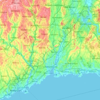
Name: Topografische Karte New Haven County, Höhe, Relief.
Durchschnittliche Höhe: 87 m
Minimale Höhe: -4 m
Maximale Höhe: 372 m
Spenden
Rüste dich für dein nächstes Abenteuer:
Als Amazon-Partner verdient diese Seite an qualifizierten Käufen, ohne dass Ihnen zusätzliche Kosten entstehen.
Andere topografische Karten
Klicken Sie auf eine Karte, um ihre Topografie, ihre Höhe und ihr Relief anzuzeigen.
Sea Bluff
United States > Connecticut > South Central Connecticut Planning Region > West Haven > West Shore
Durchschnittliche Höhe: 14 m
Killingworth Court
United States > Connecticut > South Central Connecticut Planning Region > New Haven
Durchschnittliche Höhe: 13 m
Hein Trails
United States > Connecticut > South Central Connecticut Planning Region > Bethany > Davidsons Corner
Durchschnittliche Höhe: 175 m
Indian Neck
United States > Connecticut > South Central Connecticut Planning Region > Branford
Durchschnittliche Höhe: 4 m
Spenden
Rüste dich für dein nächstes Abenteuer:
Als Amazon-Partner verdient diese Seite an qualifizierten Käufen, ohne dass Ihnen zusätzliche Kosten entstehen.
Northford
United States > Connecticut > South Central Connecticut Planning Region > North Branford
Durchschnittliche Höhe: 71 m
Ansonia
United States > Connecticut > South Central Connecticut Planning Region
Durchschnittliche Höhe: 111 m
Derby
United States > Connecticut > South Central Connecticut Planning Region
According to the United States Census Bureau, the town has a total area of 5.4 square miles (8.7 km2), of which, 5.0 square miles (13 km2) is land and 0.4 square miles (1.0 km2) (7.41%) is water. The city is home to the 417 acres (0.652 sq mi) Osbornedale State Park. Derby is divided into two main sections by…
Durchschnittliche Höhe: 79 m
Momauguin
United States > Connecticut > South Central Connecticut Planning Region > East Haven
Durchschnittliche Höhe: 3 m
Spenden
Rüste dich für dein nächstes Abenteuer:
Als Amazon-Partner verdient diese Seite an qualifizierten Käufen, ohne dass Ihnen zusätzliche Kosten entstehen.
Indian Cave
United States > Connecticut > South Central Connecticut Planning Region > Guilford
Durchschnittliche Höhe: 25 m
North Madison
United States > Connecticut > South Central Connecticut Planning Region > Madison
Durchschnittliche Höhe: 91 m
Nut Plains
United States > Connecticut > South Central Connecticut Planning Region > Guilford
Durchschnittliche Höhe: 35 m
Fort Trumbull
United States > Connecticut > South Central Connecticut Planning Region > Milford
Durchschnittliche Höhe: 7 m
Spenden
Rüste dich für dein nächstes Abenteuer:
Als Amazon-Partner verdient diese Seite an qualifizierten Käufen, ohne dass Ihnen zusätzliche Kosten entstehen.
Branford Court
United States > Connecticut > South Central Connecticut Planning Region > New Haven
Durchschnittliche Höhe: 13 m
West Shore
United States > Connecticut > South Central Connecticut Planning Region > West Haven
Durchschnittliche Höhe: 9 m
North Haven Bridge
United States > Connecticut > South Central Connecticut Planning Region > North Haven
Durchschnittliche Höhe: 22 m
Lake Whitney
United States > Connecticut > South Central Connecticut Planning Region > Hamden > Whitneyville
Durchschnittliche Höhe: 25 m
Spenden
Rüste dich für dein nächstes Abenteuer:
Als Amazon-Partner verdient diese Seite an qualifizierten Käufen, ohne dass Ihnen zusätzliche Kosten entstehen.
Jeffrey Point
United States > Connecticut > South Central Connecticut Planning Region > Branford
Durchschnittliche Höhe: 1 m
West Shore
United States > Connecticut > South Central Connecticut Planning Region > West Haven
Durchschnittliche Höhe: 9 m
South End Point
United States > Connecticut > South Central Connecticut Planning Region > East Haven > Momauguin
Durchschnittliche Höhe: 2 m
Lake Whitney
United States > Connecticut > South Central Connecticut Planning Region > Hamden
Durchschnittliche Höhe: 25 m
Spenden
Rüste dich für dein nächstes Abenteuer:
Als Amazon-Partner verdient diese Seite an qualifizierten Käufen, ohne dass Ihnen zusätzliche Kosten entstehen.
Forest Heights
United States > Connecticut > South Central Connecticut Planning Region > Milford
Durchschnittliche Höhe: 19 m
Silver Beach
United States > Connecticut > South Central Connecticut Planning Region > Milford > Fort Trumbull
Durchschnittliche Höhe: 5 m
Branford Hills
United States > Connecticut > South Central Connecticut Planning Region > Branford
Durchschnittliche Höhe: 12 m
East Peak
United States > Connecticut > South Central Connecticut Planning Region > Meriden
Durchschnittliche Höhe: 154 m
Spenden
Rüste dich für dein nächstes Abenteuer:
Als Amazon-Partner verdient diese Seite an qualifizierten Käufen, ohne dass Ihnen zusätzliche Kosten entstehen.
Momauguin
United States > Connecticut > South Central Connecticut Planning Region > East Haven
Durchschnittliche Höhe: 3 m
Silver Beach
United States > Connecticut > South Central Connecticut Planning Region > Milford
Durchschnittliche Höhe: 5 m
Nut Plains
United States > Connecticut > South Central Connecticut Planning Region > Guilford
Durchschnittliche Höhe: 35 m
South Meriden
United States > Connecticut > South Central Connecticut Planning Region > Meriden
Durchschnittliche Höhe: 55 m
Spenden
Rüste dich für dein nächstes Abenteuer:
Als Amazon-Partner verdient diese Seite an qualifizierten Käufen, ohne dass Ihnen zusätzliche Kosten entstehen.
Bayview
United States > Connecticut > South Central Connecticut Planning Region > Milford
Durchschnittliche Höhe: 5 m
Brightview
United States > Connecticut > South Central Connecticut Planning Region > New Haven
Durchschnittliche Höhe: 5 m
Fort Trumbull
United States > Connecticut > South Central Connecticut Planning Region > Milford
Durchschnittliche Höhe: 7 m
Sea Bluff
United States > Connecticut > South Central Connecticut Planning Region > West Haven > West Shore
Durchschnittliche Höhe: 14 m
Spenden
Rüste dich für dein nächstes Abenteuer:
Als Amazon-Partner verdient diese Seite an qualifizierten Käufen, ohne dass Ihnen zusätzliche Kosten entstehen.
Mount Carmel Center
United States > Connecticut > South Central Connecticut Planning Region > Hamden
Durchschnittliche Höhe: 79 m
Morningside
United States > Connecticut > South Central Connecticut Planning Region > Milford
Durchschnittliche Höhe: 5 m
East River
United States > Connecticut > South Central Connecticut Planning Region > Madison
Durchschnittliche Höhe: 9 m
Big Indian
United States > Connecticut > South Central Connecticut Planning Region > Guilford
Durchschnittliche Höhe: 41 m
Spenden
Rüste dich für dein nächstes Abenteuer:
Als Amazon-Partner verdient diese Seite an qualifizierten Käufen, ohne dass Ihnen zusätzliche Kosten entstehen.
Sunset Hill
United States > Connecticut > South Central Connecticut Planning Region > Branford
Durchschnittliche Höhe: 12 m
Sea Bluff
United States > Connecticut > South Central Connecticut Planning Region > West Haven > West Shore
Durchschnittliche Höhe: 14 m
Clark Hill
United States > Connecticut > South Central Connecticut Planning Region > Milford
Durchschnittliche Höhe: 11 m
Peter's Rock
United States > Connecticut > South Central Connecticut Planning Region > North Haven
Durchschnittliche Höhe: 38 m
Spenden
Rüste dich für dein nächstes Abenteuer:
Als Amazon-Partner verdient diese Seite an qualifizierten Käufen, ohne dass Ihnen zusätzliche Kosten entstehen.
Quinnipiac
United States > Connecticut > South Central Connecticut Planning Region > Wallingford
Durchschnittliche Höhe: 31 m
North Branford Town Green
United States > Connecticut > South Central Connecticut Planning Region > North Branford
Durchschnittliche Höhe: 44 m
Fair Haven East
United States > Connecticut > South Central Connecticut Planning Region > New Haven
Durchschnittliche Höhe: 14 m
Allingtown
United States > Connecticut > South Central Connecticut Planning Region > West Haven
Durchschnittliche Höhe: 26 m
Spenden
Rüste dich für dein nächstes Abenteuer:
Als Amazon-Partner verdient diese Seite an qualifizierten Käufen, ohne dass Ihnen zusätzliche Kosten entstehen.