
Spenden
Rüste dich für dein nächstes Abenteuer:
Als Amazon-Partner verdient diese Seite an qualifizierten Käufen, ohne dass Ihnen zusätzliche Kosten entstehen.
Topografische Karte Ansonia
Klicken Sie auf die Karte, um die Höhe anzuzeigen.
Spenden
Rüste dich für dein nächstes Abenteuer:
Als Amazon-Partner verdient diese Seite an qualifizierten Käufen, ohne dass Ihnen zusätzliche Kosten entstehen.
Über diese Karte
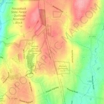
Name: Topografische Karte Ansonia, Höhe, Relief.
Durchschnittliche Höhe: 111 m
Minimale Höhe: 43 m
Maximale Höhe: 162 m
Spenden
Rüste dich für dein nächstes Abenteuer:
Als Amazon-Partner verdient diese Seite an qualifizierten Käufen, ohne dass Ihnen zusätzliche Kosten entstehen.
Andere topografische Karten
Klicken Sie auf eine Karte, um ihre Topografie, ihre Höhe und ihr Relief anzuzeigen.
Guilford
United States > Connecticut > South Central Connecticut Planning Region
Durchschnittliche Höhe: 62 m
New Haven
United States > Connecticut > South Central Connecticut Planning Region
Durchschnittliche Höhe: 20 m
Milford
United States > Connecticut > South Central Connecticut Planning Region
Durchschnittliche Höhe: 18 m
Orange
United States > Connecticut > South Central Connecticut Planning Region
Durchschnittliche Höhe: 47 m
Spenden
Rüste dich für dein nächstes Abenteuer:
Als Amazon-Partner verdient diese Seite an qualifizierten Käufen, ohne dass Ihnen zusätzliche Kosten entstehen.
Hamden
United States > Connecticut > South Central Connecticut Planning Region
Durchschnittliche Höhe: 64 m
North Haven
United States > Connecticut > South Central Connecticut Planning Region
Durchschnittliche Höhe: 38 m
Sea Bluff
United States > Connecticut > South Central Connecticut Planning Region > West Haven > West Shore
Durchschnittliche Höhe: 14 m
Meriden
United States > Connecticut > South Central Connecticut Planning Region
Durchschnittliche Höhe: 88 m
Spenden
Rüste dich für dein nächstes Abenteuer:
Als Amazon-Partner verdient diese Seite an qualifizierten Käufen, ohne dass Ihnen zusätzliche Kosten entstehen.
New Haven County
United States > Connecticut > South Central Connecticut Planning Region
The terrain is mostly flat near the coast, with low hills defining the rest of the area, rising significantly only in the north of the county. The highest elevation is close to the northernmost point in the county, found at two areas of approximately 1,050 feet (320 m) above sea level in the town of Wolcott.…
Durchschnittliche Höhe: 87 m
Bethany
United States > Connecticut > South Central Connecticut Planning Region
Durchschnittliche Höhe: 162 m
Indian Neck
United States > Connecticut > South Central Connecticut Planning Region > Branford
Durchschnittliche Höhe: 4 m
Madison
United States > Connecticut > South Central Connecticut Planning Region
Durchschnittliche Höhe: 69 m
Spenden
Rüste dich für dein nächstes Abenteuer:
Als Amazon-Partner verdient diese Seite an qualifizierten Käufen, ohne dass Ihnen zusätzliche Kosten entstehen.
Woodbridge
United States > Connecticut > South Central Connecticut Planning Region
Durchschnittliche Höhe: 96 m
Northford
United States > Connecticut > South Central Connecticut Planning Region > North Branford
Durchschnittliche Höhe: 71 m
Wallingford
United States > Connecticut > South Central Connecticut Planning Region
Durchschnittliche Höhe: 72 m
North Branford
United States > Connecticut > South Central Connecticut Planning Region
Durchschnittliche Höhe: 68 m
Spenden
Rüste dich für dein nächstes Abenteuer:
Als Amazon-Partner verdient diese Seite an qualifizierten Käufen, ohne dass Ihnen zusätzliche Kosten entstehen.
West Haven
United States > Connecticut > South Central Connecticut Planning Region
Durchschnittliche Höhe: 16 m
Borough of Woodmont
United States > Connecticut > South Central Connecticut Planning Region > Milford
A majority of the borough land mass is safely above sea level. However, it does have a few low elevation areas which are subject to flooding during very heavy storm situations (Hurricanes). The most recent, circa 2013 FEMA generated flood map is shown at the right, with the borough border roughly outlined in…
Durchschnittliche Höhe: 3 m
Momauguin
United States > Connecticut > South Central Connecticut Planning Region > East Haven
Durchschnittliche Höhe: 3 m
Indian Cave
United States > Connecticut > South Central Connecticut Planning Region > Guilford
Durchschnittliche Höhe: 25 m
Spenden
Rüste dich für dein nächstes Abenteuer:
Als Amazon-Partner verdient diese Seite an qualifizierten Käufen, ohne dass Ihnen zusätzliche Kosten entstehen.
North Madison
United States > Connecticut > South Central Connecticut Planning Region > Madison
Durchschnittliche Höhe: 91 m
Nut Plains
United States > Connecticut > South Central Connecticut Planning Region > Guilford
Durchschnittliche Höhe: 35 m
Fort Trumbull
United States > Connecticut > South Central Connecticut Planning Region > Milford
Durchschnittliche Höhe: 7 m
Guilford
United States > Connecticut > South Central Connecticut Planning Region
Durchschnittliche Höhe: 62 m
Spenden
Rüste dich für dein nächstes Abenteuer:
Als Amazon-Partner verdient diese Seite an qualifizierten Käufen, ohne dass Ihnen zusätzliche Kosten entstehen.
Branford
United States > Connecticut > South Central Connecticut Planning Region
Durchschnittliche Höhe: 17 m
West Shore
United States > Connecticut > South Central Connecticut Planning Region > West Haven
Durchschnittliche Höhe: 9 m
North Haven Bridge
United States > Connecticut > South Central Connecticut Planning Region > North Haven
Durchschnittliche Höhe: 22 m
Jeffrey Point
United States > Connecticut > South Central Connecticut Planning Region > Branford
Durchschnittliche Höhe: 1 m
Spenden
Rüste dich für dein nächstes Abenteuer:
Als Amazon-Partner verdient diese Seite an qualifizierten Käufen, ohne dass Ihnen zusätzliche Kosten entstehen.
Meriden
United States > Connecticut > South Central Connecticut Planning Region
Durchschnittliche Höhe: 88 m
West Shore
United States > Connecticut > South Central Connecticut Planning Region > West Haven
Durchschnittliche Höhe: 9 m
Hamden
United States > Connecticut > South Central Connecticut Planning Region
Durchschnittliche Höhe: 64 m
Sleeping Giant State Park
United States > Connecticut > South Central Connecticut Planning Region > Hamden
Sleeping Giant (also known as the Blue Hills and Mount Carmel), (Hobbomock in Quinnipiac), is a rugged traprock mountain with a high point of 739 feet (225 m), located eight miles (13 km) north of New Haven, Connecticut. A prominent landscape feature visible for miles, the Sleeping Giant receives its name from…
Durchschnittliche Höhe: 79 m
Spenden
Rüste dich für dein nächstes Abenteuer:
Als Amazon-Partner verdient diese Seite an qualifizierten Käufen, ohne dass Ihnen zusätzliche Kosten entstehen.
South End Point
United States > Connecticut > South Central Connecticut Planning Region > East Haven > Momauguin
Durchschnittliche Höhe: 2 m
West Haven
United States > Connecticut > South Central Connecticut Planning Region
Durchschnittliche Höhe: 16 m
Forest Heights
United States > Connecticut > South Central Connecticut Planning Region > Milford
Durchschnittliche Höhe: 19 m
New Haven
United States > Connecticut > South Central Connecticut Planning Region
Durchschnittliche Höhe: 20 m
Spenden
Rüste dich für dein nächstes Abenteuer:
Als Amazon-Partner verdient diese Seite an qualifizierten Käufen, ohne dass Ihnen zusätzliche Kosten entstehen.
Silver Beach
United States > Connecticut > South Central Connecticut Planning Region > Milford > Fort Trumbull
Durchschnittliche Höhe: 5 m
Branford Hills
United States > Connecticut > South Central Connecticut Planning Region > Branford
Durchschnittliche Höhe: 12 m
North Haven
United States > Connecticut > South Central Connecticut Planning Region
Durchschnittliche Höhe: 38 m
East Peak
United States > Connecticut > South Central Connecticut Planning Region > Meriden
Durchschnittliche Höhe: 154 m
Spenden
Rüste dich für dein nächstes Abenteuer:
Als Amazon-Partner verdient diese Seite an qualifizierten Käufen, ohne dass Ihnen zusätzliche Kosten entstehen.
New Haven
United States > Connecticut > South Central Connecticut Planning Region
Durchschnittliche Höhe: 20 m
New Haven County
United States > Connecticut > South Central Connecticut Planning Region
The terrain is mostly flat near the coast, with low hills defining the rest of the area, rising significantly only in the north of the county. The highest elevation is close to the northernmost point in the county, found at two areas of approximately 1,050 feet (320 m) above sea level in the town of Wolcott.…
Durchschnittliche Höhe: 87 m
New Haven
United States > Connecticut > South Central Connecticut Planning Region
Durchschnittliche Höhe: 20 m
West Haven
United States > Connecticut > South Central Connecticut Planning Region
Durchschnittliche Höhe: 16 m
Spenden
Rüste dich für dein nächstes Abenteuer:
Als Amazon-Partner verdient diese Seite an qualifizierten Käufen, ohne dass Ihnen zusätzliche Kosten entstehen.
Momauguin
United States > Connecticut > South Central Connecticut Planning Region > East Haven
Durchschnittliche Höhe: 3 m
Silver Beach
United States > Connecticut > South Central Connecticut Planning Region > Milford
Durchschnittliche Höhe: 5 m
Nut Plains
United States > Connecticut > South Central Connecticut Planning Region > Guilford
Durchschnittliche Höhe: 35 m
Woodbridge
United States > Connecticut > South Central Connecticut Planning Region
Durchschnittliche Höhe: 96 m
Spenden
Rüste dich für dein nächstes Abenteuer:
Als Amazon-Partner verdient diese Seite an qualifizierten Käufen, ohne dass Ihnen zusätzliche Kosten entstehen.
Milford
United States > Connecticut > South Central Connecticut Planning Region
Durchschnittliche Höhe: 18 m
Wallingford
United States > Connecticut > South Central Connecticut Planning Region
Durchschnittliche Höhe: 72 m
South Meriden
United States > Connecticut > South Central Connecticut Planning Region > Meriden
Durchschnittliche Höhe: 55 m
Bayview
United States > Connecticut > South Central Connecticut Planning Region > Milford
Durchschnittliche Höhe: 5 m
Spenden
Rüste dich für dein nächstes Abenteuer:
Als Amazon-Partner verdient diese Seite an qualifizierten Käufen, ohne dass Ihnen zusätzliche Kosten entstehen.
Bethany
United States > Connecticut > South Central Connecticut Planning Region
Durchschnittliche Höhe: 162 m
Brightview
United States > Connecticut > South Central Connecticut Planning Region > New Haven
Durchschnittliche Höhe: 5 m
Fort Trumbull
United States > Connecticut > South Central Connecticut Planning Region > Milford
Durchschnittliche Höhe: 7 m
Orange
United States > Connecticut > South Central Connecticut Planning Region
Durchschnittliche Höhe: 47 m
Spenden
Rüste dich für dein nächstes Abenteuer:
Als Amazon-Partner verdient diese Seite an qualifizierten Käufen, ohne dass Ihnen zusätzliche Kosten entstehen.
Sea Bluff
United States > Connecticut > South Central Connecticut Planning Region > West Haven > West Shore
Durchschnittliche Höhe: 14 m
Mount Carmel Center
United States > Connecticut > South Central Connecticut Planning Region > Hamden
Durchschnittliche Höhe: 79 m
Morningside
United States > Connecticut > South Central Connecticut Planning Region > Milford
Durchschnittliche Höhe: 5 m
Milford
United States > Connecticut > South Central Connecticut Planning Region
Durchschnittliche Höhe: 18 m
Spenden
Rüste dich für dein nächstes Abenteuer:
Als Amazon-Partner verdient diese Seite an qualifizierten Käufen, ohne dass Ihnen zusätzliche Kosten entstehen.
East River
United States > Connecticut > South Central Connecticut Planning Region > Madison
Durchschnittliche Höhe: 9 m
Big Indian
United States > Connecticut > South Central Connecticut Planning Region > Guilford
Durchschnittliche Höhe: 41 m
Sunset Hill
United States > Connecticut > South Central Connecticut Planning Region > Branford
Durchschnittliche Höhe: 12 m
Sea Bluff
United States > Connecticut > South Central Connecticut Planning Region > West Haven > West Shore
Durchschnittliche Höhe: 14 m
Spenden
Rüste dich für dein nächstes Abenteuer:
Als Amazon-Partner verdient diese Seite an qualifizierten Käufen, ohne dass Ihnen zusätzliche Kosten entstehen.
Clark Hill
United States > Connecticut > South Central Connecticut Planning Region > Milford
Durchschnittliche Höhe: 11 m
Peter's Rock
United States > Connecticut > South Central Connecticut Planning Region > North Haven
Durchschnittliche Höhe: 38 m
West Haven
United States > Connecticut > South Central Connecticut Planning Region
Durchschnittliche Höhe: 16 m
Milford
United States > Connecticut > South Central Connecticut Planning Region
Durchschnittliche Höhe: 18 m
Spenden
Rüste dich für dein nächstes Abenteuer:
Als Amazon-Partner verdient diese Seite an qualifizierten Käufen, ohne dass Ihnen zusätzliche Kosten entstehen.
Quinnipiac
United States > Connecticut > South Central Connecticut Planning Region > Wallingford
Durchschnittliche Höhe: 31 m
Branford
United States > Connecticut > South Central Connecticut Planning Region
Durchschnittliche Höhe: 17 m
Fair Haven East
United States > Connecticut > South Central Connecticut Planning Region > New Haven
Durchschnittliche Höhe: 14 m
New Haven
United States > Connecticut > South Central Connecticut Planning Region
Durchschnittliche Höhe: 20 m
Spenden
Rüste dich für dein nächstes Abenteuer:
Als Amazon-Partner verdient diese Seite an qualifizierten Käufen, ohne dass Ihnen zusätzliche Kosten entstehen.
North Branford
United States > Connecticut > South Central Connecticut Planning Region
Durchschnittliche Höhe: 68 m
New Haven
United States > Connecticut > South Central Connecticut Planning Region
Durchschnittliche Höhe: 20 m
Allingtown
United States > Connecticut > South Central Connecticut Planning Region > West Haven
Durchschnittliche Höhe: 26 m
Meriden
United States > Connecticut > South Central Connecticut Planning Region
Durchschnittliche Höhe: 92 m
Spenden
Rüste dich für dein nächstes Abenteuer:
Als Amazon-Partner verdient diese Seite an qualifizierten Käufen, ohne dass Ihnen zusätzliche Kosten entstehen.
Milford
United States > Connecticut > South Central Connecticut Planning Region
Durchschnittliche Höhe: 18 m
Milford
United States > Connecticut > South Central Connecticut Planning Region
Durchschnittliche Höhe: 18 m