
Topografische Karte Constanța
Interaktive Karte
Klicken Sie auf die Karte, um die Höhe anzuzeigen.
Über diese Karte
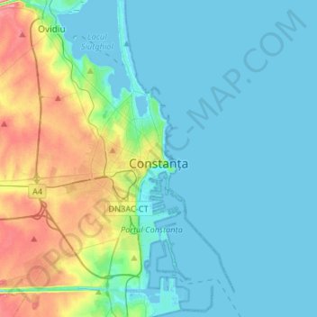
Name: Topografische Karte Constanța, Höhe, Relief.
Ort: Constanța, Constanta Metropolitan Area, Constanța, Romania (44.08421 28.50911 44.27281 28.71360)
Durchschnittliche Höhe: 19 m
Minimale Höhe: -5 m
Maximale Höhe: 91 m
Spring arrives early but it is quite cool. Often in April and May the Black Sea coast is one of the coolest places in Romania found at an altitude lower than 500 m (1,640 ft).
Andere topografische Karten
Klicken Sie auf eine Karte, um ihre Topografie, ihre Höhe und ihr Relief anzuzeigen.
Eforie Nord
Eforie Nord, Eforie, Constanta Metropolitan Area, Constanța, 905350, Romania
Durchschnittliche Höhe: 11 m
Mamaia-Sat
Romania > Constanța > Năvodari > Mamaia-Sat
Mamaia-Sat, Năvodari, Constanta Metropolitan Area, Constanța, 905701, Romania
Durchschnittliche Höhe: 7 m