
Topografische Karte Bominaco
Klicken Sie auf die Karte, um die Höhe anzuzeigen.
Über diese Karte
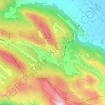
Name: Topografische Karte Bominaco, Höhe, Relief.
Ort: Bominaco, Caporciano, L'Aquila, Abruzzo, 67020, Italy (42.22381 13.63779 42.26381 13.67779)
Durchschnittliche Höhe: 962 m
Minimale Höhe: 732 m
Maximale Höhe: 1’229 m
Andere topografische Karten
Klicken Sie auf eine Karte, um ihre Topografie, ihre Höhe und ihr Relief anzuzeigen.
Cansano
Cansano is located 9 km (5.6 mi) from Sulmona, on a hill near the Valle Peligna, at 835 m (2,740 ft) m above sea level. The minimum altitude of the municipality of Cansano is 599 m (1,965 ft), while the maximum is 1,792 m (5,879 ft). The area of the municipal territory is 37.70 km2 (14.56 sq mi).
Durchschnittliche Höhe: 1’115 m