
Topografische Karte Navelli
Klicken Sie auf die Karte, um die Höhe anzuzeigen.
Über diese Karte
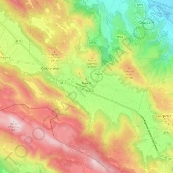
Name: Topografische Karte Navelli, Höhe, Relief.
Ort: Navelli, L'Aquila, Abruzzo, Italy (42.19369 13.69070 42.27840 13.80020)
Durchschnittliche Höhe: 801 m
Minimale Höhe: 327 m
Maximale Höhe: 1’298 m
Andere topografische Karten
Klicken Sie auf eine Karte, um ihre Topografie, ihre Höhe und ihr Relief anzuzeigen.
Assergi
Italy > Abruzzo > L'Aquila > L'Aquila
Assergi is a frazione of the comune of L'Aquila, located about 11 km (6.8 mi) from the capital. With a population of just over 500, it is situated at an altitude of approximately 1,000 meters, below the western slope of the Gran Sasso in a small plain called the Piana di Assergi (Plain of Assergi). Assergi was…
Durchschnittliche Höhe: 1’035 m