
Spenden
Rüste dich für dein nächstes Abenteuer:
Als Amazon-Partner verdient diese Seite an qualifizierten Käufen, ohne dass Ihnen zusätzliche Kosten entstehen.
Topografische Karte Murphy
Klicken Sie auf die Karte, um die Höhe anzuzeigen.
Spenden
Rüste dich für dein nächstes Abenteuer:
Als Amazon-Partner verdient diese Seite an qualifizierten Käufen, ohne dass Ihnen zusätzliche Kosten entstehen.
Murphy
Murphy is located in southwestern North Carolina, approximately halfway between Atlanta, Georgia and Knoxville, Tennessee. The topography consists of gentle rolling hills and mountains with tall peaks, including ranges from 1800 ft to more than 5000 ft elevation. The location in the Blue Ridge Mountains has helped the community retain a fairly rural character, surrounded by wildlife such as bear, deer, fox and recently reintroduced elk.
Spenden
Rüste dich für dein nächstes Abenteuer:
Als Amazon-Partner verdient diese Seite an qualifizierten Käufen, ohne dass Ihnen zusätzliche Kosten entstehen.
Über diese Karte
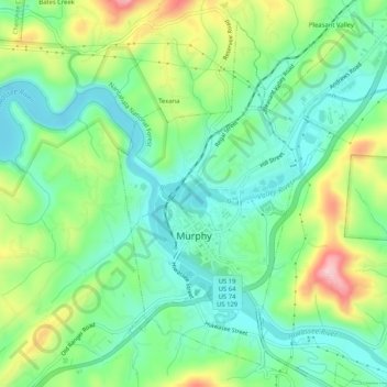
Name: Topografische Karte Murphy, Höhe, Relief.
Ort: Murphy, Cherokee County, North Carolina, United States (35.07100 -84.04487 35.11326 -84.00244)
Durchschnittliche Höhe: 514 m
Minimale Höhe: 448 m
Maximale Höhe: 648 m
Spenden
Rüste dich für dein nächstes Abenteuer:
Als Amazon-Partner verdient diese Seite an qualifizierten Käufen, ohne dass Ihnen zusätzliche Kosten entstehen.
Andere topografische Karten
Klicken Sie auf eine Karte, um ihre Topografie, ihre Höhe und ihr Relief anzuzeigen.
Spenden
Rüste dich für dein nächstes Abenteuer:
Als Amazon-Partner verdient diese Seite an qualifizierten Käufen, ohne dass Ihnen zusätzliche Kosten entstehen.
Spenden
Rüste dich für dein nächstes Abenteuer:
Als Amazon-Partner verdient diese Seite an qualifizierten Käufen, ohne dass Ihnen zusätzliche Kosten entstehen.
Hideaway Mountain Lake Dam
United States > North Carolina > Cherokee County
Durchschnittliche Höhe: 658 m
Murphy
United States > North Carolina > Cherokee County > Murphy
Murphy is located in southwestern North Carolina, approximately halfway between Atlanta, Georgia and Knoxville, Tennessee. The topography sonsists of gentle rolling hills and mountains with tall peaks, including ranges from 1800 ft to more than 5000 ft elevation. The location in the Blue Ridge Mountains has…
Durchschnittliche Höhe: 528 m
Spenden
Rüste dich für dein nächstes Abenteuer:
Als Amazon-Partner verdient diese Seite an qualifizierten Käufen, ohne dass Ihnen zusätzliche Kosten entstehen.
Spenden
Rüste dich für dein nächstes Abenteuer:
Als Amazon-Partner verdient diese Seite an qualifizierten Käufen, ohne dass Ihnen zusätzliche Kosten entstehen.
Pleasant Hill
United States > North Carolina > Cherokee County > Pleasant Hill
Durchschnittliche Höhe: 464 m