
Spenden
Rüste dich für dein nächstes Abenteuer:
Als Amazon-Partner verdient diese Seite an qualifizierten Käufen, ohne dass Ihnen zusätzliche Kosten entstehen.
Topografische Karte Tipton Knob
Klicken Sie auf die Karte, um die Höhe anzuzeigen.
Spenden
Rüste dich für dein nächstes Abenteuer:
Als Amazon-Partner verdient diese Seite an qualifizierten Käufen, ohne dass Ihnen zusätzliche Kosten entstehen.
Über diese Karte
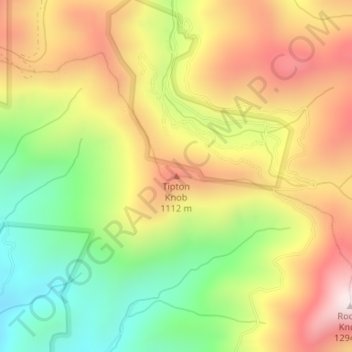
Name: Topografische Karte Tipton Knob, Höhe, Relief.
Ort: Tipton Knob, Cherokee County, North Carolina, United States (35.23829 -84.07236 35.23839 -84.07226)
Durchschnittliche Höhe: 936 m
Minimale Höhe: 607 m
Maximale Höhe: 1’269 m
Spenden
Rüste dich für dein nächstes Abenteuer:
Als Amazon-Partner verdient diese Seite an qualifizierten Käufen, ohne dass Ihnen zusätzliche Kosten entstehen.
Andere topografische Karten
Klicken Sie auf eine Karte, um ihre Topografie, ihre Höhe und ihr Relief anzuzeigen.
Murphy
United States > North Carolina > Cherokee County
Murphy is located in southwestern North Carolina, approximately halfway between Atlanta, Georgia and Knoxville, Tennessee. The topography consists of gentle rolling hills and mountains with tall peaks, including ranges from 1800 ft to more than 5000 ft elevation. The location in the Blue Ridge Mountains has…
Durchschnittliche Höhe: 514 m
Andrews
United States > North Carolina > Cherokee County
Until the early 1960s, all Andrews schools were located next to each other on the property of the current elementary school. A 1935 topographic map of Andrews shows each school building, marked with a flag, located adjacent to each other on Walnut Street (now Jean Christy Avenue) and Fourth Street. The current…
Durchschnittliche Höhe: 593 m
Murphy
United States > North Carolina > Cherokee County
Murphy has a humid subtropical climate, (Cfa) according to the Köppen classification, with hot, humid summers and cool to mild winters, with low temperatures significantly cooler than other parts of the Southeast, due in part to the elevation. Like the rest of the southeastern U.S., Murphy receives abundant…
Durchschnittliche Höhe: 514 m
Murphy
United States > North Carolina > Cherokee County
Murphy is located in southwestern North Carolina, approximately halfway between Atlanta, Georgia and Knoxville, Tennessee. The topography consists of gentle rolling hills and mountains with tall peaks, including ranges from 1800 ft to more than 5000 ft elevation. The location in the Blue Ridge Mountains has…
Durchschnittliche Höhe: 514 m
Spenden
Rüste dich für dein nächstes Abenteuer:
Als Amazon-Partner verdient diese Seite an qualifizierten Käufen, ohne dass Ihnen zusätzliche Kosten entstehen.
Cherokee County Community
United States > North Carolina > Cherokee County
Durchschnittliche Höhe: 710 m
Andrews
United States > North Carolina > Cherokee County
Until the early 1960s, all Andrews schools were located next to each other on the property of the current elementary school. A 1935 topographic map of Andrews shows each school building, marked with a flag, located adjacent to each other on Walnut Street (now Jean Christy Avenue) and Fourth Street. The current…
Durchschnittliche Höhe: 593 m