
Topografische Karte Lake Adger
Interaktive Karte
Klicken Sie auf die Karte, um die Höhe anzuzeigen.
Über diese Karte
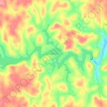
Name: Topografische Karte Lake Adger, Höhe, Relief.
Ort: Lake Adger, Polk County, North Carolina, United States (35.32636 -82.23552 35.34852 -82.18700)
Durchschnittliche Höhe: 312 m
Minimale Höhe: 254 m
Maximale Höhe: 358 m
Andere topografische Karten
Klicken Sie auf eine Karte, um ihre Topografie, ihre Höhe und ihr Relief anzuzeigen.
Hickory Grove
United States > North Carolina > Polk County
Hickory Grove, Polk County, North Carolina, United States
Durchschnittliche Höhe: 281 m
Mill Spring
United States > North Carolina > Polk County
Mill Spring, Polk County, North Carolina, 28756, United States
Durchschnittliche Höhe: 318 m
Green River
United States > North Carolina > Polk County
Green River, Polk County, North Carolina, 28756, United States
Durchschnittliche Höhe: 538 m
Tryon
United States > North Carolina > Polk County
Tryon, Polk County, North Carolina, United States
Durchschnittliche Höhe: 333 m
Melrose
United States > North Carolina > Polk County > Melrose
Melrose, Polk County, North Carolina, 28773, United States
Durchschnittliche Höhe: 610 m
Saluda
United States > North Carolina > Polk County
Saluda, Polk County, North Carolina, 28773, United States
Durchschnittliche Höhe: 635 m
Green Creek
United States > North Carolina > Polk County > Green Creek
Green Creek, Polk County, North Carolina, United States
Durchschnittliche Höhe: 290 m