
Topografische Karte Saluda
Interaktive Karte
Klicken Sie auf die Karte, um die Höhe anzuzeigen.
Über diese Karte
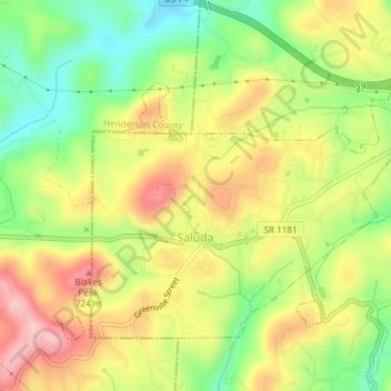
Name: Topografische Karte Saluda, Höhe, Relief.
Ort: Saluda, Polk County, North Carolina, 28773, United States (35.22812 -82.36302 35.25086 -82.32559)
Durchschnittliche Höhe: 635 m
Minimale Höhe: 498 m
Maximale Höhe: 735 m
Saluda is located in southwestern Polk County at 35°14′16″N 82°20′49″W / 35.237856°N 82.346870°W / 35.237856; -82.346870 (35.237856, -82.346870). Two small parts of the city extend west and north into Henderson County. The elevation on Main Street is 2,097 feet (639 m) above sea level, while the elevation at the bottom end of the Saluda Grade, in Tryon, is 1,080 feet (329.1 m).
Andere topografische Karten
Klicken Sie auf eine Karte, um ihre Topografie, ihre Höhe und ihr Relief anzuzeigen.
Hickory Grove
United States > North Carolina > Polk County
Hickory Grove, Polk County, North Carolina, United States
Durchschnittliche Höhe: 281 m
Mill Spring
United States > North Carolina > Polk County
Mill Spring, Polk County, North Carolina, 28756, United States
Durchschnittliche Höhe: 318 m
Green River
United States > North Carolina > Polk County
Green River, Polk County, North Carolina, 28756, United States
Durchschnittliche Höhe: 538 m
Lake Adger
United States > North Carolina > Polk County
Lake Adger, Polk County, North Carolina, United States
Durchschnittliche Höhe: 312 m
Tryon
United States > North Carolina > Polk County
Tryon, Polk County, North Carolina, United States
Durchschnittliche Höhe: 333 m
Melrose
United States > North Carolina > Polk County > Melrose
Melrose, Polk County, North Carolina, 28773, United States
Durchschnittliche Höhe: 610 m
Green Creek
United States > North Carolina > Polk County > Green Creek
Green Creek, Polk County, North Carolina, United States
Durchschnittliche Höhe: 290 m