
Topografische Karte Alibates Flint Quarries National Monument
Interaktive Karte
Klicken Sie auf die Karte, um die Höhe anzuzeigen.
Über diese Karte
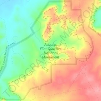
Name: Topografische Karte Alibates Flint Quarries National Monument, Höhe, Relief.
Durchschnittliche Höhe: 947 m
Minimale Höhe: 890 m
Maximale Höhe: 998 m
Andere topografische Karten
Klicken Sie auf eine Karte, um ihre Topografie, ihre Höhe und ihr Relief anzuzeigen.
Amarillo
United States > Texas > Potter County
Amarillo, Potter County, Texas, United States
Durchschnittliche Höhe: 1’097 m
Amarillo
United States > Texas > Potter County
Amarillo, Potter County, Texas, United States
Durchschnittliche Höhe: 1’097 m
Bushland
United States > Texas > Potter County
Bushland, Potter County, Texas, 79012, United States
Durchschnittliche Höhe: 1’166 m
Amarillo
United States > Texas > Potter County > Amarillo
Amarillo, Potter County, Texas, 79105, United States
Durchschnittliche Höhe: 1’090 m