
Topografische Karte Catania
Interaktive Karte
Klicken Sie auf die Karte, um die Höhe anzuzeigen.
Über diese Karte
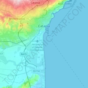
Name: Topografische Karte Catania, Höhe, Relief.
Ort: Catania, Sicily, Italy (37.35830 14.93587 37.56239 15.12579)
Durchschnittliche Höhe: 50 m
Minimale Höhe: -1 m
Maximale Höhe: 441 m
Around 263 BC, the city was variously known as Catĭna (Latin: [ˈkatɪna]) and Catăna (Latin: [ˈkatana]; Ancient Greek: Κατάνη [katánɛː]). The former has been primarily used for its supposed assonance with catina, the Latin feminization of the name catinus. Catinus has two meanings: "a gulf, a basin or a bay" and "a bowl, a vessel or a trough", thanks to the city's distinctive topography.
Andere topografische Karten
Klicken Sie auf eine Karte, um ihre Topografie, ihre Höhe und ihr Relief anzuzeigen.
Zafferana Etnea
Zafferana Etnea, Catania, Sicily, 95019, Italy
Durchschnittliche Höhe: 771 m
Biancavilla
Biancavilla, Catania, Sicily, 95033, Italy
Durchschnittliche Höhe: 687 m
Mofeta dei Palici
Italy > Sicily > Catania > Mineo
Mofeta dei Palici, Mineo, Catania, Sicily, 95044, Italy
Durchschnittliche Höhe: 125 m
Etna
Italy > Sicily > Catania > Zafferana Etnea
Etna, Zafferana Etnea, Catania, Sicily, 95019, Italy
Durchschnittliche Höhe: 2’976 m
Mount Etna
Mount Etna, Catania, Sicily, 95036, Italy
Durchschnittliche Höhe: 1’157 m