
Topografische Karte Butte County
Interaktive Karte
Klicken Sie auf die Karte, um die Höhe anzuzeigen.
Über diese Karte
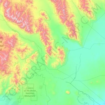
Name: Topografische Karte Butte County, Höhe, Relief.
Ort: Butte County, Idaho, United States of America (43.28487 -113.79803 44.23439 -112.69193)
Durchschnittliche Höhe: 1’914 m
Minimale Höhe: 1’401 m
Maximale Höhe: 3’720 m
Andere topografische Karten
Klicken Sie auf eine Karte, um ihre Topografie, ihre Höhe und ihr Relief anzuzeigen.
Snake River
United States of America > Idaho
Snake River, Washington County, Idaho, 83672, United States of America
Durchschnittliche Höhe: 644 m
Sawtooth National Forest
United States of America > Idaho > Rupert
Sawtooth National Forest, Sharon Court, Rupert, Minidoka County, Idaho, 83350, United States of America
Durchschnittliche Höhe: 1’608 m
Genesee
United States of America > Idaho > Genesee
Genesee, Latah County, Idaho, 83832, United States of America
Durchschnittliche Höhe: 824 m
Chinese Peak
United States of America > Idaho
Chinese Peak, Bannock County, Idaho, United States of America
Durchschnittliche Höhe: 1’830 m
Camas County
United States of America > Idaho
Camas County, Idaho, United States of America
Durchschnittliche Höhe: 2’002 m
Eagle Rock
United States of America > Idaho
Eagle Rock, Idaho County, Idaho, United States of America
Durchschnittliche Höhe: 1’164 m
Teton
United States of America > Idaho > Teton
Teton, Fremont County, Idaho, 83451, United States of America
Durchschnittliche Höhe: 1’509 m
Springston
United States of America > Idaho
Springston, Kootenai County, Idaho, 83833, United States of America
Durchschnittliche Höhe: 721 m