
Topografische Karte Camas County
Interaktive Karte
Klicken Sie auf die Karte, um die Höhe anzuzeigen.
Über diese Karte
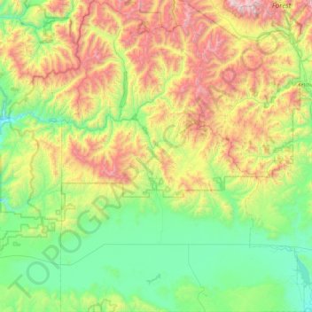
Name: Topografische Karte Camas County, Höhe, Relief.
Ort: Camas County, Idaho, United States of America (43.19842 -115.08668 43.85861 -114.37772)
Durchschnittliche Höhe: 2’002 m
Minimale Höhe: 1’375 m
Maximale Höhe: 3’406 m
U.S. Highway 20 runs east–west through the county's center, at elevations just over 5,000 feet (1,520 m) above sea level, connecting west to Mountain Home in Elmore County; to the east it intersects State Highway 75 in Blaine County. The northern terminus of State Highway 46 is at US-20, four miles (6.4 km) east of Fairfield; it runs south over the Mount Bennett Hills into Gooding County and on to Gooding.
Andere topografische Karten
Klicken Sie auf eine Karte, um ihre Topografie, ihre Höhe und ihr Relief anzuzeigen.
Snake River
United States of America > Idaho
Snake River, Washington County, Idaho, 83672, United States of America
Durchschnittliche Höhe: 644 m
Sawtooth National Forest
United States of America > Idaho > Rupert
Sawtooth National Forest, Sharon Court, Rupert, Minidoka County, Idaho, 83350, United States of America
Durchschnittliche Höhe: 1’608 m
Genesee
United States of America > Idaho > Genesee
Genesee, Latah County, Idaho, 83832, United States of America
Durchschnittliche Höhe: 824 m
Butte County
United States of America > Idaho
Butte County, Idaho, United States of America
Durchschnittliche Höhe: 1’914 m
Chinese Peak
United States of America > Idaho
Chinese Peak, Bannock County, Idaho, United States of America
Durchschnittliche Höhe: 1’830 m
Eagle Rock
United States of America > Idaho
Eagle Rock, Idaho County, Idaho, United States of America
Durchschnittliche Höhe: 1’164 m
Teton
United States of America > Idaho > Teton
Teton, Fremont County, Idaho, 83451, United States of America
Durchschnittliche Höhe: 1’509 m
Springston
United States of America > Idaho
Springston, Kootenai County, Idaho, 83833, United States of America
Durchschnittliche Höhe: 721 m