
Spenden
Rüste dich für dein nächstes Abenteuer:
Als Amazon-Partner verdient diese Seite an qualifizierten Käufen, ohne dass Ihnen zusätzliche Kosten entstehen.
Topografische Karte Lakemont
Klicken Sie auf die Karte, um die Höhe anzuzeigen.
Spenden
Rüste dich für dein nächstes Abenteuer:
Als Amazon-Partner verdient diese Seite an qualifizierten Käufen, ohne dass Ihnen zusätzliche Kosten entstehen.
Über diese Karte
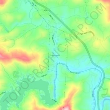
Name: Topografische Karte Lakemont, Höhe, Relief.
Ort: Lakemont, Rabun County, Georgia, 30581, United States (34.76204 -83.43628 34.80204 -83.39628)
Durchschnittliche Höhe: 547 m
Minimale Höhe: 474 m
Maximale Höhe: 684 m
Spenden
Rüste dich für dein nächstes Abenteuer:
Als Amazon-Partner verdient diese Seite an qualifizierten Käufen, ohne dass Ihnen zusätzliche Kosten entstehen.
Andere topografische Karten
Klicken Sie auf eine Karte, um ihre Topografie, ihre Höhe und ihr Relief anzuzeigen.
Sky Valley
United States > Georgia > Rabun County
According to the United States Census Bureau, the city has a total area of 3.0 square miles (7.8 km2), all land. The elevation of the valley floor is approximately 3100 feet above sea level, while areas within the city limits on the slopes of Rabun Bald exceed 4200 feet. Sky Valley is Georgia's highest…
Durchschnittliche Höhe: 973 m
Tiger
United States > Georgia > Rabun County
Tiger lies in the extreme northeastern part of the state, just a few miles west of the Georgia-South Carolina border, and a few miles south of the Georgia-North Carolina border. The town's elevation is 1,962 feet (598 m), with several wooded hilltops reaching elevations of 2,100 to 2,200 feet. The town sits at…
Durchschnittliche Höhe: 608 m
Mountain City
United States > Georgia > Rabun County
Mountain City is an incorporated town in Rabun County, Georgia, United States. The population was 904 at the 2020 census. The town straddles the Eastern Continental Divide in a deep gap in the Blue Ridge Mountain front. The gap allows U.S. Route 441 to cross the range at an elevation of 2168 feet without the…
Durchschnittliche Höhe: 747 m
Spenden
Rüste dich für dein nächstes Abenteuer:
Als Amazon-Partner verdient diese Seite an qualifizierten Käufen, ohne dass Ihnen zusätzliche Kosten entstehen.
Spenden
Rüste dich für dein nächstes Abenteuer:
Als Amazon-Partner verdient diese Seite an qualifizierten Käufen, ohne dass Ihnen zusätzliche Kosten entstehen.
Sky Valley
United States > Georgia > Rabun County
According to the United States Census Bureau, the city has a total area of 3.0 square miles (7.8 km2), all land. The elevation of the valley floor is approximately 3100 feet above sea level, while areas within the city limits on the slopes of Rabun Bald exceed 4200 feet. Sky Valley is Georgia's highest…
Durchschnittliche Höhe: 973 m
Tiger
United States > Georgia > Rabun County
Tiger lies in the extreme northeastern part of the state, just a few miles west of the Georgia-South Carolina border, and a few miles south of the Georgia-North Carolina border. The town's elevation is 1,962 feet (598 m), with several wooded hilltops reaching elevations of 2,100 to 2,200 feet. The town sits at…
Durchschnittliche Höhe: 608 m