
Spenden
Rüste dich für dein nächstes Abenteuer:
Als Amazon-Partner verdient diese Seite an qualifizierten Käufen, ohne dass Ihnen zusätzliche Kosten entstehen.
Topografische Karte Mountain City
Klicken Sie auf die Karte, um die Höhe anzuzeigen.
Spenden
Rüste dich für dein nächstes Abenteuer:
Als Amazon-Partner verdient diese Seite an qualifizierten Käufen, ohne dass Ihnen zusätzliche Kosten entstehen.
Mountain City
Mountain City is an incorporated town in Rabun County, Georgia, United States. The population was 904 at the 2020 census. The town straddles the Eastern Continental Divide in a deep gap in the Blue Ridge Mountain front. The gap allows U.S. Route 441 to cross the range at an elevation of 2168 feet without the significant grade required by roadways at most other mountain passes along the Georgia Blue Ridge.
Spenden
Rüste dich für dein nächstes Abenteuer:
Als Amazon-Partner verdient diese Seite an qualifizierten Käufen, ohne dass Ihnen zusätzliche Kosten entstehen.
Über diese Karte
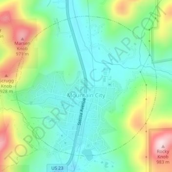
Name: Topografische Karte Mountain City, Höhe, Relief.
Ort: Mountain City, Rabun County, Georgia, 30562, United States (34.90855 -83.39892 34.93057 -83.37193)
Durchschnittliche Höhe: 747 m
Minimale Höhe: 635 m
Maximale Höhe: 985 m
Spenden
Rüste dich für dein nächstes Abenteuer:
Als Amazon-Partner verdient diese Seite an qualifizierten Käufen, ohne dass Ihnen zusätzliche Kosten entstehen.
Andere topografische Karten
Klicken Sie auf eine Karte, um ihre Topografie, ihre Höhe und ihr Relief anzuzeigen.
Spenden
Rüste dich für dein nächstes Abenteuer:
Als Amazon-Partner verdient diese Seite an qualifizierten Käufen, ohne dass Ihnen zusätzliche Kosten entstehen.
Clayton
United States > Georgia > Rabun County > Clayton
According to the United States Census Bureau, the city has a total area of 3.1 square miles (8.0 km2), all of it land. The elevation of Clayton's downtown area is 1,925 feet (587 m). A number of hilltops within the city limits exceed 2,200 feet.
Durchschnittliche Höhe: 634 m