
Topografische Karte San Luis
Interaktive Karte
Klicken Sie auf die Karte, um die Höhe anzuzeigen.
Über diese Karte
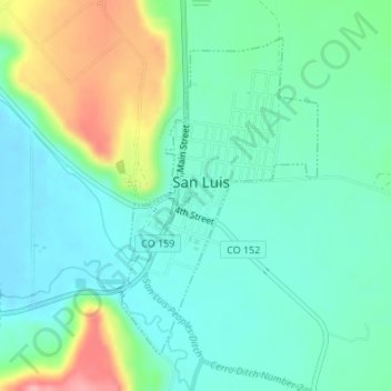
Name: Topografische Karte San Luis, Höhe, Relief.
Ort: San Luis, Costilla County, Colorado, 81152, United States (37.18929 -105.43065 37.21120 -105.41364)
Durchschnittliche Höhe: 2’448 m
Minimale Höhe: 2’414 m
Maximale Höhe: 2’538 m
Andere topografische Karten
Klicken Sie auf eine Karte, um ihre Topografie, ihre Höhe und ihr Relief anzuzeigen.
Fort Garland
United States > Colorado > Costilla County
Fort Garland, Costilla County, Colorado, United States
Durchschnittliche Höhe: 2’427 m
Fort Garland
United States > Colorado > Costilla County
Fort Garland, Costilla County, Colorado, 81133, United States
Durchschnittliche Höhe: 2’441 m
Forbes Park Dam
United States > Colorado > Costilla County
Forbes Park Dam, Costilla County, Colorado, United States
Durchschnittliche Höhe: 2’958 m
Red Mountain
United States > Colorado > Costilla County
Red Mountain, Costilla County, Colorado, United States
Durchschnittliche Höhe: 3’862 m
Blanca
United States > Colorado > Costilla County
Blanca, Costilla County, Colorado, United States
Durchschnittliche Höhe: 2’366 m
San Acacio
United States > Colorado > Costilla County
San Acacio, Costilla County, Colorado, United States
Durchschnittliche Höhe: 2’354 m
Culebra Peak
United States > Colorado > Costilla County
Culebra Peak, Costilla County, Colorado, United States
Durchschnittliche Höhe: 3’920 m