
Topografische Karte Fort Garland
Interaktive Karte
Klicken Sie auf die Karte, um die Höhe anzuzeigen.
Über diese Karte
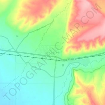
Name: Topografische Karte Fort Garland, Höhe, Relief.
Durchschnittliche Höhe: 2’441 m
Minimale Höhe: 2’380 m
Maximale Höhe: 2’530 m
Fort Garland is located at an elevation of 7,936 ft (2,419 m) in northern Costilla County. Fort Garland is at the crossroads of U.S. Route 160 and Colorado State Highway 159, which leads south towards Taos and Santa Fe, New Mexico. The town of Blanca is 4 miles (6.4 km) west on U.S. Route 160. Walsenburg is 47 miles (76 km) to the east, across the Sangre de Cristo Range.
Andere topografische Karten
Klicken Sie auf eine Karte, um ihre Topografie, ihre Höhe und ihr Relief anzuzeigen.
Fort Garland
United States > Colorado > Costilla County
Fort Garland, Costilla County, Colorado, United States
Durchschnittliche Höhe: 2’427 m
Forbes Park Dam
United States > Colorado > Costilla County
Forbes Park Dam, Costilla County, Colorado, United States
Durchschnittliche Höhe: 2’958 m
Red Mountain
United States > Colorado > Costilla County
Red Mountain, Costilla County, Colorado, United States
Durchschnittliche Höhe: 3’862 m
Blanca
United States > Colorado > Costilla County
Blanca, Costilla County, Colorado, United States
Durchschnittliche Höhe: 2’366 m
San Luis
United States > Colorado > Costilla County
San Luis, Costilla County, Colorado, 81152, United States
Durchschnittliche Höhe: 2’448 m
San Acacio
United States > Colorado > Costilla County
San Acacio, Costilla County, Colorado, United States
Durchschnittliche Höhe: 2’354 m
Culebra Peak
United States > Colorado > Costilla County
Culebra Peak, Costilla County, Colorado, United States
Durchschnittliche Höhe: 3’920 m