
Topografische Karte Desert
Klicken Sie auf die Karte, um die Höhe anzuzeigen.
Über diese Karte
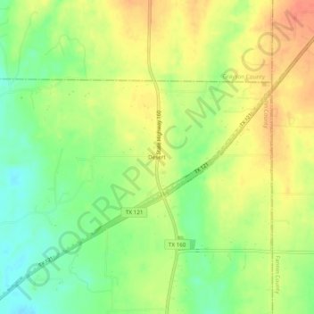
Name: Topografische Karte Desert, Höhe, Relief.
Ort: Desert, Collin County, Texas, United States (33.36836 -96.42210 33.40836 -96.38210)
Durchschnittliche Höhe: 206 m
Minimale Höhe: 179 m
Maximale Höhe: 231 m
Andere topografische Karten
Klicken Sie auf eine Karte, um ihre Topografie, ihre Höhe und ihr Relief anzuzeigen.
Plano
United States > Texas > Collin County
At first, Plano's population grew slowly, reaching 1,304 in 1900 and 3,695 in 1960. By 1970, Plano began to feel some of the boom its neighbors had experienced after World War II. A series of public works projects and a change in taxes that removed the farming community from the town helped increase the…
Durchschnittliche Höhe: 196 m
Frisco
United States > Texas > Collin County
In 1902, a line of the St. Louis-San Francisco Railway was being built through the area, and periodic watering stops were needed along the route for the steam locomotives. The current settlement of Lebanon was on the Preston Ridge, and was too high in elevation, so the watering stop was placed about 4 miles (6…
Durchschnittliche Höhe: 201 m
Plano
United States > Texas > Collin County
At first, Plano's population grew slowly, reaching 1,304 in 1900 and 3,695 in 1960. By 1970, Plano began to feel some of the boom its neighbors had experienced after World War II. A series of public works projects and a change in taxes that removed the farming community from the town helped increase the…
Durchschnittliche Höhe: 196 m
Frisco
United States > Texas > Collin County
In 1902, a line of the St. Louis–San Francisco Railway ("the Frisco") was being built through the area, and periodic watering stops were needed along the route for the steam locomotives. The current settlement of Lebanon was on Preston Ridge and was too high in elevation, so the watering stop was placed…
Durchschnittliche Höhe: 201 m
Plano
United States > Texas > Collin County
At first, Plano's population grew slowly, reaching 1,304 in 1900 and 3,695 in 1960. By 1970, Plano began to feel some of the boom its neighbors had experienced after World War II. A series of public works projects and a change in taxes that removed the farming community from the town helped increase the…
Durchschnittliche Höhe: 196 m