Geolokalisieren

Topografische Karte Allen

Klicken Sie auf die Karte, um die Höhe anzuzeigen.

Über diese Karte

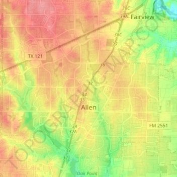
Name: Topografische Karte Allen, Höhe, Relief.

Ort: Allen, Collin County, Texas, United States (33.07084 -96.73667 33.15801 -96.60899)

Durchschnittliche Höhe: 200 m

Minimale Höhe: 159 m

Maximale Höhe: 233 m

Andere topografische Karten

Klicken Sie auf eine Karte, um ihre Topografie, ihre Höhe und ihr Relief anzuzeigen.

Princeton

United States > Texas > Collin County

Durchschnittliche Höhe: 172 m

Altoga

United States > Texas > Collin County

Durchschnittliche Höhe: 176 m

Lavon

United States > Texas > Collin County

Durchschnittliche Höhe: 156 m

Clear Lake

United States > Texas > Collin County

Durchschnittliche Höhe: 157 m

Russell Creek Park

United States > Texas > Collin County > Plano

Durchschnittliche Höhe: 227 m

Frisco

United States > Texas > Collin County > Frisco

When the Dallas area was being settled by American pioneers, many of the settlers traveled by wagon trains along the Shawnee Trail. This trail became the Preston Trail, and later, Preston Road. With all of this activity, the community of Lebanon was founded along this trail, and was granted a U.S. post office…

Durchschnittliche Höhe: 191 m

Wetsel

United States > Texas > Collin County > Allen

Durchschnittliche Höhe: 200 m

Princeton

United States > Texas > Collin County

Durchschnittliche Höhe: 172 m

Lavon

United States > Texas > Collin County

Durchschnittliche Höhe: 156 m

Desert

United States > Texas > Collin County

Durchschnittliche Höhe: 206 m

Beverly Hill

United States > Texas > Collin County

Durchschnittliche Höhe: 154 m

Desert

United States > Texas > Collin County

Durchschnittliche Höhe: 206 m

Plano

United States > Texas > Collin County > Plano

At first, Plano's population grew slowly, reaching 1,304 in 1900 and 3,695 in 1960. By 1970, Plano began to feel some of the boom its neighbors had experienced after World War II. A series of public works projects and a change in taxes that removed the farming community from the town helped increase the…

Durchschnittliche Höhe: 181 m

Rüste dich für dein nächstes Abenteuer:

🔥Campingkocher & Outdoor‑Kocher - Leistungsstarke Kocher für Wander‑ und Trekkingtouren
📍GPS‑Zubehör - Zubehör für GPS‑Geräte und Navigation
🛶Wasserdichte Taschen - Schützt Ausrüstung bei Regen und Wasseraktivitäten
🎿Schneeschuhe - Erkundung tief verschneiter Landschaften abseits der Piste
🔦Kopflampen für Outdoor - Helle und langlebige Lampen für Nacht‑ und Frühstarts

Als Amazon-Partner verdient diese Seite an qualifizierten Käufen, ohne dass Ihnen zusätzliche Kosten entstehen.