
Topografische Karte Encinitas
Interaktive Karte
Klicken Sie auf die Karte, um die Höhe anzuzeigen.
Über diese Karte
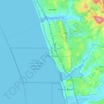
Name: Topografische Karte Encinitas, Höhe, Relief.
Ort: Encinitas, San Diego County, California, United States (32.99599 -117.36829 33.08872 -117.19557)
Durchschnittliche Höhe: 32 m
Minimale Höhe: -1 m
Maximale Höhe: 317 m
Encinitas lies on rugged coastal terrace. The city is bisected by a low-lying coastal ridge that separates New and Old Encinitas. In the north of the city, the coast rises in elevation and the land is raised up in the form of many coastal bluffs. These cliffs are subject to collapsing on the narrow beach. The city is bounded by Batiquitos Lagoon to the north and San Elijo Lagoon to the south.
Andere topografische Karten
Klicken Sie auf eine Karte, um ihre Topografie, ihre Höhe und ihr Relief anzuzeigen.
Coronado
United States > California > San Diego County
Coronado, San Diego County, California, United States
Durchschnittliche Höhe: 5 m
Alpine
United States > California > San Diego County
Alpine, San Diego County, CAL Fire Southern Region, California, 91901, United States
Durchschnittliche Höhe: 581 m
San Diego
United States > California > San Diego County
San Diego, San Diego County, California, United States
Durchschnittliche Höhe: 125 m
Oceanside
United States > California > San Diego County
Oceanside, San Diego County, CAL Fire Southern Region, California, United States
Durchschnittliche Höhe: 33 m
Oak Park
United States > California > San Diego County > San Diego
Oak Park, San Diego, San Diego County, California, 92105, United States
Durchschnittliche Höhe: 108 m
Del Mar
United States > California > San Diego County > Del Mar
Del Mar, San Diego County, California, United States
Durchschnittliche Höhe: 24 m
Lemon Grove
United States > California > San Diego County
Lemon Grove, San Diego County, CAL Fire Southern Region, California, 91945, United States
Durchschnittliche Höhe: 129 m