
Topografische Karte Alpine
Interaktive Karte
Klicken Sie auf die Karte, um die Höhe anzuzeigen.
Über diese Karte
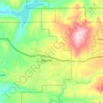
Name: Topografische Karte Alpine, Höhe, Relief.
Durchschnittliche Höhe: 581 m
Minimale Höhe: 170 m
Maximale Höhe: 1’272 m
Alpine sits on both sides of Interstate 8 at the eastern extent of the California coastal region and the western extent of the Peninsular Ranges, about 30 miles (48 km) east of downtown San Diego, at an elevation of about 2,000 feet (610 m).
Andere topografische Karten
Klicken Sie auf eine Karte, um ihre Topografie, ihre Höhe und ihr Relief anzuzeigen.
Coronado
United States > California > San Diego County
Coronado, San Diego County, California, United States
Durchschnittliche Höhe: 5 m
San Diego
United States > California > San Diego County
San Diego, San Diego County, California, United States
Durchschnittliche Höhe: 125 m
Oceanside
United States > California > San Diego County
Oceanside, San Diego County, CAL Fire Southern Region, California, United States
Durchschnittliche Höhe: 33 m
Encinitas
United States > California > San Diego County
Encinitas, San Diego County, California, United States
Durchschnittliche Höhe: 32 m
Oak Park
United States > California > San Diego County > San Diego
Oak Park, San Diego, San Diego County, California, 92105, United States
Durchschnittliche Höhe: 108 m
Del Mar
United States > California > San Diego County > Del Mar
Del Mar, San Diego County, California, United States
Durchschnittliche Höhe: 24 m
Lemon Grove
United States > California > San Diego County
Lemon Grove, San Diego County, CAL Fire Southern Region, California, 91945, United States
Durchschnittliche Höhe: 129 m