
Spenden
Rüste dich für dein nächstes Abenteuer:
Als Amazon-Partner verdient diese Seite an qualifizierten Käufen, ohne dass Ihnen zusätzliche Kosten entstehen.
Topografische Karte Brady Lake
Klicken Sie auf die Karte, um die Höhe anzuzeigen.
Spenden
Rüste dich für dein nächstes Abenteuer:
Als Amazon-Partner verdient diese Seite an qualifizierten Käufen, ohne dass Ihnen zusätzliche Kosten entstehen.
Über diese Karte
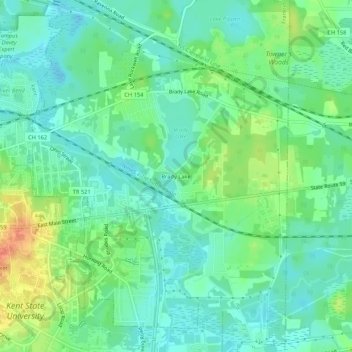
Name: Topografische Karte Brady Lake, Höhe, Relief.
Durchschnittliche Höhe: 328 m
Minimale Höhe: 312 m
Maximale Höhe: 363 m
Spenden
Rüste dich für dein nächstes Abenteuer:
Als Amazon-Partner verdient diese Seite an qualifizierten Käufen, ohne dass Ihnen zusätzliche Kosten entstehen.
Andere topografische Karten
Klicken Sie auf eine Karte, um ihre Topografie, ihre Höhe und ihr Relief anzuzeigen.
Kent
United States > Ohio > Portage County
Located on the western end of the Glaciated Allegheny Plateau, the topography of Kent includes rolling hills and varied terrain. The Cuyahoga River passes through the city, cutting a gorge with a drop of nearly 40 feet (10 m) adjacent to the downtown area. The United States Geological Survey lists the city's…
Durchschnittliche Höhe: 328 m
Spenden
Rüste dich für dein nächstes Abenteuer:
Als Amazon-Partner verdient diese Seite an qualifizierten Käufen, ohne dass Ihnen zusätzliche Kosten entstehen.
Wingfoot Lake
United States > Ohio > Portage County > Suffield > Mishler
Durchschnittliche Höhe: 354 m
Spenden
Rüste dich für dein nächstes Abenteuer:
Als Amazon-Partner verdient diese Seite an qualifizierten Käufen, ohne dass Ihnen zusätzliche Kosten entstehen.
Spenden
Rüste dich für dein nächstes Abenteuer:
Als Amazon-Partner verdient diese Seite an qualifizierten Käufen, ohne dass Ihnen zusätzliche Kosten entstehen.
Kent
United States > Ohio > Portage County
Located on the western end of the Glaciated Allegheny Plateau, the topography of Kent includes rolling hills and varied terrain. The Cuyahoga River passes through the city, cutting a gorge with a drop of nearly 40 feet (10 m) adjacent to the downtown area. The United States Geological Survey lists the city's…
Durchschnittliche Höhe: 328 m
Spenden
Rüste dich für dein nächstes Abenteuer:
Als Amazon-Partner verdient diese Seite an qualifizierten Käufen, ohne dass Ihnen zusätzliche Kosten entstehen.
Kent
United States > Ohio > Portage County
Located on the western end of the Glaciated Allegheny Plateau, the topography of Kent includes rolling hills and varied terrain. The Cuyahoga River passes through the city, cutting a gorge with a drop of nearly 40 feet (10 m) adjacent to the downtown area. The United States Geological Survey lists the city's…
Durchschnittliche Höhe: 328 m
Little Mussy Lake
United States > Ohio > Portage County > Rootstown Township
Durchschnittliche Höhe: 330 m
Spenden
Rüste dich für dein nächstes Abenteuer:
Als Amazon-Partner verdient diese Seite an qualifizierten Käufen, ohne dass Ihnen zusätzliche Kosten entstehen.