
Spenden
Rüste dich für dein nächstes Abenteuer:
Als Amazon-Partner verdient diese Seite an qualifizierten Käufen, ohne dass Ihnen zusätzliche Kosten entstehen.
Topografische Karte Kent
Klicken Sie auf die Karte, um die Höhe anzuzeigen.
Spenden
Rüste dich für dein nächstes Abenteuer:
Als Amazon-Partner verdient diese Seite an qualifizierten Käufen, ohne dass Ihnen zusätzliche Kosten entstehen.
Kent
Located on the western end of the Glaciated Allegheny Plateau, the topography of Kent includes rolling hills and varied terrain. The Cuyahoga River passes through the city, cutting a gorge with a drop of nearly 40 feet (10 m) adjacent to the downtown area. The United States Geological Survey lists the city's elevation at 1,056 feet (322 m) above sea level at a point near Kent's geographic center. Elevations vary slightly within the city limits with several buildings on the Kent State University campus at altitudes in excess of 1,160 feet (350 m) and points as high as 1,200 feet (370 m). According to the United States Census Bureau, as of 2010 the city has a total area of 9.28 square miles (24.04 km2), of which 9.17 square miles (23.75 km2) is land and 0.11 square miles (0.28 km2) is water.
Spenden
Rüste dich für dein nächstes Abenteuer:
Als Amazon-Partner verdient diese Seite an qualifizierten Käufen, ohne dass Ihnen zusätzliche Kosten entstehen.
Über diese Karte
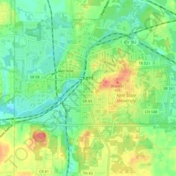
Name: Topografische Karte Kent, Höhe, Relief.
Ort: Kent, Portage County, Ohio, United States (41.11765 -81.39246 41.17781 -81.30999)
Durchschnittliche Höhe: 328 m
Minimale Höhe: 304 m
Maximale Höhe: 369 m
Spenden
Rüste dich für dein nächstes Abenteuer:
Als Amazon-Partner verdient diese Seite an qualifizierten Käufen, ohne dass Ihnen zusätzliche Kosten entstehen.
Andere topografische Karten
Klicken Sie auf eine Karte, um ihre Topografie, ihre Höhe und ihr Relief anzuzeigen.
Little Mussy Lake
United States > Ohio > Portage County > Rootstown Township
Durchschnittliche Höhe: 330 m
Spenden
Rüste dich für dein nächstes Abenteuer:
Als Amazon-Partner verdient diese Seite an qualifizierten Käufen, ohne dass Ihnen zusätzliche Kosten entstehen.