
Topografische Karte Hamlet
Interaktive Karte
Klicken Sie auf die Karte, um die Höhe anzuzeigen.
Über diese Karte
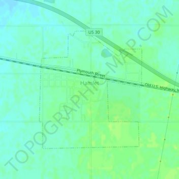
Name: Topografische Karte Hamlet, Höhe, Relief.
Ort: Hamlet, Starke County, Indiana, United States (41.37103 -86.59261 41.38875 -86.57201)
Durchschnittliche Höhe: 213 m
Minimale Höhe: 207 m
Maximale Höhe: 218 m
Andere topografische Karten
Klicken Sie auf eine Karte, um ihre Topografie, ihre Höhe und ihr Relief anzuzeigen.
Koontz Lake
United States > Indiana > Starke County
Koontz Lake, Starke County, Indiana, United States
Durchschnittliche Höhe: 221 m
North Judson
United States > Indiana > Starke County
North Judson, Starke County, Indiana, 46366, United States
Durchschnittliche Höhe: 215 m
Bass Lake
United States > Indiana > Starke County
Bass Lake, Starke County, Indiana, 45534, United States
Durchschnittliche Höhe: 220 m
Knox
United States > Indiana > Starke County > Knox
Knox, Starke County, Indiana, United States
Durchschnittliche Höhe: 216 m
Grovertown
United States > Indiana > Starke County > Grovertown
Grovertown, Starke County, Indiana, 46531, United States
Durchschnittliche Höhe: 221 m