
Topografische Karte Koontz Lake
Interaktive Karte
Klicken Sie auf die Karte, um die Höhe anzuzeigen.
Über diese Karte
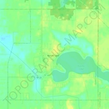
Name: Topografische Karte Koontz Lake, Höhe, Relief.
Ort: Koontz Lake, Starke County, Indiana, United States (41.40384 -86.50520 41.43302 -86.45881)
Durchschnittliche Höhe: 221 m
Minimale Höhe: 210 m
Maximale Höhe: 232 m
Andere topografische Karten
Klicken Sie auf eine Karte, um ihre Topografie, ihre Höhe und ihr Relief anzuzeigen.
Hamlet
United States > Indiana > Starke County
Hamlet, Starke County, Indiana, United States
Durchschnittliche Höhe: 213 m
North Judson
United States > Indiana > Starke County
North Judson, Starke County, Indiana, 46366, United States
Durchschnittliche Höhe: 215 m
Bass Lake
United States > Indiana > Starke County
Bass Lake, Starke County, Indiana, 45534, United States
Durchschnittliche Höhe: 220 m
Knox
United States > Indiana > Starke County > Knox
Knox, Starke County, Indiana, United States
Durchschnittliche Höhe: 216 m
Grovertown
United States > Indiana > Starke County > Grovertown
Grovertown, Starke County, Indiana, 46531, United States
Durchschnittliche Höhe: 221 m