
Spenden
Rüste dich für dein nächstes Abenteuer:
Als Amazon-Partner verdient diese Seite an qualifizierten Käufen, ohne dass Ihnen zusätzliche Kosten entstehen.
Topografische Karte Zorn
Klicken Sie auf die Karte, um die Höhe anzuzeigen.
Spenden
Rüste dich für dein nächstes Abenteuer:
Als Amazon-Partner verdient diese Seite an qualifizierten Käufen, ohne dass Ihnen zusätzliche Kosten entstehen.
Über diese Karte
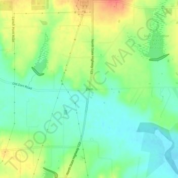
Name: Topografische Karte Zorn, Höhe, Relief.
Ort: Zorn, Guadalupe County, Texas, United States (29.73300 -97.96806 29.77300 -97.92806)
Durchschnittliche Höhe: 169 m
Minimale Höhe: 147 m
Maximale Höhe: 200 m
Spenden
Rüste dich für dein nächstes Abenteuer:
Als Amazon-Partner verdient diese Seite an qualifizierten Käufen, ohne dass Ihnen zusätzliche Kosten entstehen.
Andere topografische Karten
Klicken Sie auf eine Karte, um ihre Topografie, ihre Höhe und ihr Relief anzuzeigen.
Seguin
United States > Texas > Guadalupe County
The elevation at the courthouse is 522 feet (159 m) above mean sea level.
Durchschnittliche Höhe: 172 m
Spenden
Rüste dich für dein nächstes Abenteuer:
Als Amazon-Partner verdient diese Seite an qualifizierten Käufen, ohne dass Ihnen zusätzliche Kosten entstehen.
Spenden
Rüste dich für dein nächstes Abenteuer:
Als Amazon-Partner verdient diese Seite an qualifizierten Käufen, ohne dass Ihnen zusätzliche Kosten entstehen.
Seguin
United States > Texas > Guadalupe County
The elevation at the courthouse is 522 feet (159 m) above mean sea level.
Durchschnittliche Höhe: 172 m