Geolokalisieren

Topografische Karte Cibolo

Interaktive Karte

Klicken Sie auf die Karte, um die Höhe anzuzeigen.

Über diese Karte

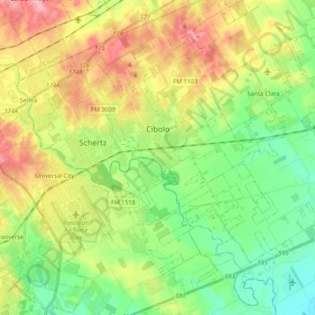
Name: Topografische Karte Cibolo, Höhe, Relief.

Ort: Cibolo, Guadalupe County, Texas, 78108, United States (29.49503 -98.27420 29.61847 -98.09733)

Durchschnittliche Höhe: 220 m

Minimale Höhe: 172 m

Maximale Höhe: 291 m

Andere topografische Karten

Klicken Sie auf eine Karte, um ihre Topografie, ihre Höhe und ihr Relief anzuzeigen.

Seguin

United States > Texas > Guadalupe County

Seguin, Guadalupe County, Texas, United States

Durchschnittliche Höhe: 172 m

Schertz

United States > Texas > Guadalupe County

Schertz, Guadalupe County, Texas, 78154, United States

Durchschnittliche Höhe: 232 m

Zorn

United States > Texas > Guadalupe County

Zorn, Guadalupe County, Texas, United States

Durchschnittliche Höhe: 169 m

Kingsbury

United States > Texas > Guadalupe County

Kingsbury, Guadalupe County, Texas, United States

Durchschnittliche Höhe: 166 m