
Topografische Karte Marmolada
Interaktive Karte
Klicken Sie auf die Karte, um die Höhe anzuzeigen.
Über diese Karte
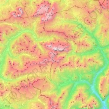
Name: Topografische Karte Marmolada, Höhe, Relief.
Ort: Marmolada, Belluno, Veneto, Italy (46.34877 11.66152 46.49878 12.01600)
Durchschnittliche Höhe: 1’896 m
Minimale Höhe: 632 m
Maximale Höhe: 3’320 m
The ridge is composed of several summits, decreasing in altitude from west to east: Punta Penia 3,343 metres (10,968 ft), Punta Rocca 3,309 metres (10,856 ft), Punta Ombretta 3,230 metres (10,600 ft), Monte Serauta 3,069 metres (10,069 ft), and Pizzo Serauta 3,035 metres (9,957 ft). An aerial tramway goes to the top of Punta Rocca. During the ski season the Marmolada's main ski run is opened for skiers and snowboarders alike, making it possible to ski down into the valley.
Andere topografische Karten
Klicken Sie auf eine Karte, um ihre Topografie, ihre Höhe und ihr Relief anzuzeigen.
Cibiana di Cadore
Cibiana di Cadore, Belluno, Veneto, 32040, Italy
Durchschnittliche Höhe: 1’460 m
Pieve d'Alpago
Pieve d'Alpago, Alpago, Belluno, Veneto, 32016, Italy
Durchschnittliche Höhe: 879 m
Borgo Valbelluna
Borgo Valbelluna, Belluno, Veneto, Italy
Durchschnittliche Höhe: 578 m
Santa Croce del Lago
Italy > Veneto > Belluno > Farra d'Alpago
Santa Croce del Lago, Farra d'Alpago, Alpago, Belluno, Veneto, 32016, Italy
Durchschnittliche Höhe: 730 m
Lago di Corlo
Italy > Veneto > Belluno > Rocca d'Arsiè
Lago di Corlo, Rocca d'Arsiè, Arsiè, Belluno, Veneto, Italy
Durchschnittliche Höhe: 592 m
Colle Santa Lucia
Colle Santa Lucia, Belluno, Veneto, Italy
Durchschnittliche Höhe: 1’728 m
Falzarego Pass
Italy > Veneto > Belluno > Cortina d'Ampezzo
Falzarego Pass, Cortina d'Ampezzo, Belluno, Veneto, Italy
Durchschnittliche Höhe: 2’179 m
Valparola Pass
Valparola Pass, Livinallongo del Col di Lana, Belluno, Veneto, Italy
Durchschnittliche Höhe: 2’199 m
Cortina d'Ampezzo
Cortina d'Ampezzo, Belluno, Veneto, 32043, Italy
Durchschnittliche Höhe: 1’974 m
Selva di Cadore
Selva di Cadore, Belluno, Veneto, Italy
Durchschnittliche Höhe: 1’696 m
Misurina
Italy > Veneto > Belluno > Auronzo di Cadore
Misurina, Auronzo di Cadore, Belluno, Veneto, Italy
Durchschnittliche Höhe: 1’954 m
Monte Piana
Italy > Veneto > Belluno > Auronzo di Cadore
Monte Piana, Auronzo di Cadore, Belluno, Veneto, Italy
Durchschnittliche Höhe: 1’850 m
Zwölferkofel - Croda dei Toni
Italy > Veneto > Belluno > Auronzo di Cadore
Zwölferkofel - Croda dei Toni, Auronzo di Cadore, Belluno, Veneto, Italy
Durchschnittliche Höhe: 2’367 m
Pocol
Italy > Veneto > Belluno > Cortina d'Ampezzo
Pocol, Cortina d'Ampezzo, Belluno, Veneto, 32043, Italy
Durchschnittliche Höhe: 1’448 m
Tre Cime di Lavaredo - Drei Zinnen
Italy > Veneto > Belluno > Auronzo di Cadore
Tre Cime di Lavaredo - Drei Zinnen, Auronzo di Cadore, Pustertal - Val Pusteria, Belluno, Veneto, 39034, Italy
Durchschnittliche Höhe: 2’242 m
Ponte nelle Alpi
Ponte nelle Alpi, Belluno, Veneto, 32014, Italy
Durchschnittliche Höhe: 739 m
Gruppo del Pomagagnon
Italy > Veneto > Belluno > Cortina d'Ampezzo
Gruppo del Pomagagnon, Cortina d'Ampezzo, Belluno, Veneto, 32043, Italy
Durchschnittliche Höhe: 1’758 m
Pieve di Cadore
Italy > Veneto > Belluno > Pieve di Cadore > Pieve di Cadore
Pieve di Cadore, Belluno, Veneto, 32044, Italy
Durchschnittliche Höhe: 1’116 m
Mottes
Italy > Veneto > Belluno > Rivamonte Agordino > Rivamonte Agordino
Mottes, Rivamonte Agordino, Belluno, Veneto, 32021, Italy
Durchschnittliche Höhe: 994 m
Cinque Torri
Italy > Veneto > Belluno > Cortina d'Ampezzo
Cinque Torri, Cortina d'Ampezzo, Belluno, Veneto, Italy
Durchschnittliche Höhe: 2’071 m