
Topografische Karte Bannack
Interaktive Karte
Klicken Sie auf die Karte, um die Höhe anzuzeigen.
Über diese Karte
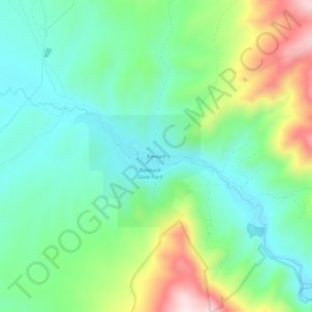
Name: Topografische Karte Bannack, Höhe, Relief.
Ort: Bannack, Beaverhead County, Montana, United States (45.14103 -113.01559 45.18103 -112.97559)
Durchschnittliche Höhe: 1’877 m
Minimale Höhe: 1’737 m
Maximale Höhe: 2’190 m
Andere topografische Karten
Klicken Sie auf eine Karte, um ihre Topografie, ihre Höhe und ihr Relief anzuzeigen.
Polaris
United States > Montana > Beaverhead County
Polaris, Beaverhead County, Montana, United States
Durchschnittliche Höhe: 2’016 m
Monida
United States > Montana > Beaverhead County
Monida, Beaverhead County, Montana, United States
Durchschnittliche Höhe: 2’111 m
Chief Joseph Pass
United States > Montana > Beaverhead County
Chief Joseph Pass, Beaverhead County, Montana, United States
Durchschnittliche Höhe: 2’150 m
Dillon
United States > Montana > Beaverhead County
Dillon, Beaverhead County, Montana, United States
Durchschnittliche Höhe: 1’562 m
Jackson
United States > Montana > Beaverhead County > Jackson
Jackson, Beaverhead County, Montana, 59736, United States
Durchschnittliche Höhe: 1’995 m
Dillon
United States > Montana > Beaverhead County > Dillon
Dillon, Beaverhead County, Montana, United States
Durchschnittliche Höhe: 1’592 m