
Spenden
Rüste dich für dein nächstes Abenteuer:
Als Amazon-Partner verdient diese Seite an qualifizierten Käufen, ohne dass Ihnen zusätzliche Kosten entstehen.
Topografische Karte Monida
Klicken Sie auf die Karte, um die Höhe anzuzeigen.
Spenden
Rüste dich für dein nächstes Abenteuer:
Als Amazon-Partner verdient diese Seite an qualifizierten Käufen, ohne dass Ihnen zusätzliche Kosten entstehen.
Über diese Karte
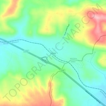
Name: Topografische Karte Monida, Höhe, Relief.
Ort: Monida, Beaverhead County, Montana, United States (44.54186 -112.33361 44.58186 -112.29361)
Durchschnittliche Höhe: 2’111 m
Minimale Höhe: 2’050 m
Maximale Höhe: 2’216 m
Spenden
Rüste dich für dein nächstes Abenteuer:
Als Amazon-Partner verdient diese Seite an qualifizierten Käufen, ohne dass Ihnen zusätzliche Kosten entstehen.
Andere topografische Karten
Klicken Sie auf eine Karte, um ihre Topografie, ihre Höhe und ihr Relief anzuzeigen.
Dillon
United States > Montana > Beaverhead County
Dillon is located at 45°12′57″N 112°38′3″W / 45.21583°N 112.63417°W / 45.21583; -112.63417 (45.215735, -112.634055), approximately 40 miles (64 km) east of the Continental Divide. It lies at an elevation of 5,102 feet (1,555 m).
Durchschnittliche Höhe: 1’562 m
Wisdom
United States > Montana > Beaverhead County > Wisdom
Wisdom is located at 45°36′58″N 113°26′59″W / 45.61611°N 113.44972°W / 45.61611; -113.44972 (45.616120, -113.449742). According to the United States Census Bureau, the CDP has a total area of 0.99 square miles (2.56 km2), of which 0.98 square miles (2.54 km2) is land and 0.0077 square…
Durchschnittliche Höhe: 1’848 m
Spenden
Rüste dich für dein nächstes Abenteuer:
Als Amazon-Partner verdient diese Seite an qualifizierten Käufen, ohne dass Ihnen zusätzliche Kosten entstehen.
Dillon
United States > Montana > Beaverhead County
Dillon is located at 45°12′57″N 112°38′3″W / 45.21583°N 112.63417°W / 45.21583; -112.63417 (45.215735, -112.634055), approximately 40 miles (64 km) east of the Continental Divide. It lies at an elevation of 5,102 feet (1,555 m).
Durchschnittliche Höhe: 1’562 m
Wisdom
United States > Montana > Beaverhead County > Wisdom
Wisdom is located at 45°36′58″N 113°26′59″W / 45.61611°N 113.44972°W / 45.61611; -113.44972 (45.616120, -113.449742). According to the United States Census Bureau, the CDP has a total area of 0.99 square miles (2.56 km2), of which 0.98 square miles (2.54 km2) is land and 0.0077 square…
Durchschnittliche Höhe: 1’848 m
Dillon
United States > Montana > Beaverhead County
Dillon is situated on the Beaverhead River. It lies at an elevation of 5,102 feet (1,555 m).
Durchschnittliche Höhe: 1’562 m
Dillon
United States > Montana > Beaverhead County
Dillon is located at 45°12′57″N 112°38′3″W / 45.21583°N 112.63417°W / 45.21583; -112.63417 (45.215735, -112.634055), approximately 40 miles (64 km) east of the Continental Divide. It lies at an elevation of 5,102 feet (1,555 m).
Durchschnittliche Höhe: 1’562 m
Spenden
Rüste dich für dein nächstes Abenteuer:
Als Amazon-Partner verdient diese Seite an qualifizierten Käufen, ohne dass Ihnen zusätzliche Kosten entstehen.