
Spenden
Rüste dich für dein nächstes Abenteuer:
Als Amazon-Partner verdient diese Seite an qualifizierten Käufen, ohne dass Ihnen zusätzliche Kosten entstehen.
Topografische Karte White Hall
Klicken Sie auf die Karte, um die Höhe anzuzeigen.
Spenden
Rüste dich für dein nächstes Abenteuer:
Als Amazon-Partner verdient diese Seite an qualifizierten Käufen, ohne dass Ihnen zusätzliche Kosten entstehen.
Über diese Karte
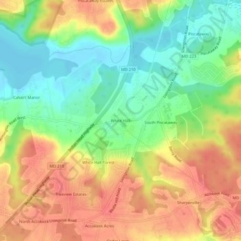
Name: Topografische Karte White Hall, Höhe, Relief.
Durchschnittliche Höhe: 36 m
Minimale Höhe: -2 m
Maximale Höhe: 72 m
Spenden
Rüste dich für dein nächstes Abenteuer:
Als Amazon-Partner verdient diese Seite an qualifizierten Käufen, ohne dass Ihnen zusätzliche Kosten entstehen.
Andere topografische Karten
Klicken Sie auf eine Karte, um ihre Topografie, ihre Höhe und ihr Relief anzuzeigen.
College Park
United States > Maryland > Prince George's County
College Park features a relatively flat terrain typical of the Atlantic Coastal Plain, with an average elevation of around 100 feet above sea level. The landscape is characterized by gently rolling hills, particularly in the northern and western parts, while lower-lying areas can be found near the various…
Durchschnittliche Höhe: 38 m
L P Cosca Regional Park
United States > Maryland > Prince George's County
Durchschnittliche Höhe: 60 m
Spenden
Rüste dich für dein nächstes Abenteuer:
Als Amazon-Partner verdient diese Seite an qualifizierten Käufen, ohne dass Ihnen zusätzliche Kosten entstehen.
West Laurel
United States > Maryland > Prince George's County > West Laurel
Durchschnittliche Höhe: 101 m
Temple Hills
United States > Maryland > Prince George's County > Temple Hills
Durchschnittliche Höhe: 64 m
Fort Washington
United States > Maryland > Prince George's County > Fort Washington
Durchschnittliche Höhe: 28 m
Spenden
Rüste dich für dein nächstes Abenteuer:
Als Amazon-Partner verdient diese Seite an qualifizierten Käufen, ohne dass Ihnen zusätzliche Kosten entstehen.
Forestville
United States > Maryland > Prince George's County > Forestville
Durchschnittliche Höhe: 73 m
Spenden
Rüste dich für dein nächstes Abenteuer:
Als Amazon-Partner verdient diese Seite an qualifizierten Käufen, ohne dass Ihnen zusätzliche Kosten entstehen.
National Harbor
United States > Maryland > Prince George's County > National Harbor
Durchschnittliche Höhe: 31 m
East Riverdale
United States > Maryland > Prince George's County > East Riverdale
Durchschnittliche Höhe: 36 m
Accokeek
United States > Maryland > Prince George's County > Accokeek
According to the United States Census Bureau, the place has a total area of 28.803 square miles (74.60 km2), of which 27.436 square miles (71.06 km2) is land and 1.367 square miles (3.54 km2) is water. Accokeek has an average elevation of 194 feet (59 m).
Durchschnittliche Höhe: 46 m
Spenden
Rüste dich für dein nächstes Abenteuer:
Als Amazon-Partner verdient diese Seite an qualifizierten Käufen, ohne dass Ihnen zusätzliche Kosten entstehen.
Anacostia River Stream Valley Park
United States > Maryland > Prince George's County > Cottage City
Durchschnittliche Höhe: 25 m
Spenden
Rüste dich für dein nächstes Abenteuer:
Als Amazon-Partner verdient diese Seite an qualifizierten Käufen, ohne dass Ihnen zusätzliche Kosten entstehen.
Hyattsville
United States > Maryland > Prince George's County
Downtown Hyattsville underwent revitalization in the early 2000s with the development of Arts District Hyattsville, part of the Gateway Arts District, a private project which includes townhomes, live-work units, and retail space. The master developer of the 25-acre neighborhood was Bethesda-based EYA, and was…
Durchschnittliche Höhe: 24 m
Temple Hills
United States > Maryland > Prince George's County > Temple Hills
Durchschnittliche Höhe: 64 m
Spenden
Rüste dich für dein nächstes Abenteuer:
Als Amazon-Partner verdient diese Seite an qualifizierten Käufen, ohne dass Ihnen zusätzliche Kosten entstehen.
Greenbelt Park
United States > Maryland > Prince George's County > Greenbelt
Durchschnittliche Höhe: 40 m
Forestville
United States > Maryland > Prince George's County > Forestville
Durchschnittliche Höhe: 73 m
Spenden
Rüste dich für dein nächstes Abenteuer:
Als Amazon-Partner verdient diese Seite an qualifizierten Käufen, ohne dass Ihnen zusätzliche Kosten entstehen.
College Park
United States > Maryland > Prince George's County
The Lakeland neighborhood was developed beginning in 1890 around the Baltimore and Ohio Railroad, whose Branchville and Calvert Road depots were located approximately one mile to the north and south, respectively. Lakeland was created by Edwin Newman, who improved the original 238 acres (0.96 km2) located to…
Durchschnittliche Höhe: 38 m
Spenden
Rüste dich für dein nächstes Abenteuer:
Als Amazon-Partner verdient diese Seite an qualifizierten Käufen, ohne dass Ihnen zusätzliche Kosten entstehen.
Silver Hill
United States > Maryland > Prince George's County > Silver Hill
Durchschnittliche Höhe: 79 m
Spenden
Rüste dich für dein nächstes Abenteuer:
Als Amazon-Partner verdient diese Seite an qualifizierten Käufen, ohne dass Ihnen zusätzliche Kosten entstehen.
Forestville
United States > Maryland > Prince George's County > Forestville
Durchschnittliche Höhe: 73 m
Camp Springs
United States > Maryland > Prince George's County > Camp Springs
Durchschnittliche Höhe: 72 m
Spenden
Rüste dich für dein nächstes Abenteuer:
Als Amazon-Partner verdient diese Seite an qualifizierten Käufen, ohne dass Ihnen zusätzliche Kosten entstehen.
Fort Washington
United States > Maryland > Prince George's County > Fort Washington
Durchschnittliche Höhe: 28 m
Glenn Dale
United States > Maryland > Prince George's County > Glenn Dale
Durchschnittliche Höhe: 52 m
Spenden
Rüste dich für dein nächstes Abenteuer:
Als Amazon-Partner verdient diese Seite an qualifizierten Käufen, ohne dass Ihnen zusätzliche Kosten entstehen.
Spenden
Rüste dich für dein nächstes Abenteuer:
Als Amazon-Partner verdient diese Seite an qualifizierten Käufen, ohne dass Ihnen zusätzliche Kosten entstehen.
College Park
United States > Maryland > Prince George's County
The Lakeland neighborhood was developed beginning in 1890 around the Baltimore and Ohio Railroad, whose Branchville and Calvert Road depots were located approximately one mile to the north and south, respectively. Lakeland was created by Edwin Newman, who improved the original 238 acres (0.96 km2) located to…
Durchschnittliche Höhe: 38 m
Hyattsville
United States > Maryland > Prince George's County
Downtown Hyattsville underwent revitalization in the early 2000s with the development of Arts District Hyattsville, part of the Gateway Arts District, a private project which includes townhomes, live-work units, and retail space. The master developer of the 25-acre neighborhood was Bethesda-based EYA, and was…
Durchschnittliche Höhe: 24 m
Camp Springs
United States > Maryland > Prince George's County > Camp Springs
Durchschnittliche Höhe: 72 m
College Park
United States > Maryland > Prince George's County
The Lakeland neighborhood was developed beginning in 1890 around the Baltimore and Ohio Railroad, whose Branchville and Calvert Road depots were located approximately one mile to the north and south, respectively. Lakeland was created by Edwin Newman, who improved the original 238 acres (0.96 km2) located to…
Durchschnittliche Höhe: 38 m
Spenden
Rüste dich für dein nächstes Abenteuer:
Als Amazon-Partner verdient diese Seite an qualifizierten Käufen, ohne dass Ihnen zusätzliche Kosten entstehen.
Brandywine
United States > Maryland > Prince George's County > Brandywine
Durchschnittliche Höhe: 61 m
Langley Park
United States > Maryland > Prince George's County > Langley Park
Durchschnittliche Höhe: 53 m
Spenden
Rüste dich für dein nächstes Abenteuer:
Als Amazon-Partner verdient diese Seite an qualifizierten Käufen, ohne dass Ihnen zusätzliche Kosten entstehen.
Seabrook
United States > Maryland > Prince George's County > Glenn Dale
Seabrook takes its name from Thomas Seabrook, who was a topographical engineer with the Pennsylvania Railroad. He originally built three cottages and a park with fenced-in tame deer in the area near the rail station[5] in the early 1870s.
Durchschnittliche Höhe: 49 m
Fort Washington
United States > Maryland > Prince George's County > Fort Washington
Durchschnittliche Höhe: 28 m
Spenden
Rüste dich für dein nächstes Abenteuer:
Als Amazon-Partner verdient diese Seite an qualifizierten Käufen, ohne dass Ihnen zusätzliche Kosten entstehen.
Mitchellville
United States > Maryland > Prince George's County > Mitchellville
Durchschnittliche Höhe: 46 m