
Spenden
Rüste dich für dein nächstes Abenteuer:
Als Amazon-Partner verdient diese Seite an qualifizierten Käufen, ohne dass Ihnen zusätzliche Kosten entstehen.
Topografische Karte College Park
Klicken Sie auf die Karte, um die Höhe anzuzeigen.
Spenden
Rüste dich für dein nächstes Abenteuer:
Als Amazon-Partner verdient diese Seite an qualifizierten Käufen, ohne dass Ihnen zusätzliche Kosten entstehen.
College Park
The Lakeland neighborhood was developed beginning in 1890 around the Baltimore and Ohio Railroad, whose Branchville and Calvert Road depots were located approximately one mile to the north and south, respectively. Lakeland was created by Edwin Newman, who improved the original 238 acres (0.96 km2) located to the west of the railroad. He also built a number of the original homes, a small town hall, and a general store. The area was originally envisioned as a resort-type community. However, due to the flood-prone, low-lying topography, the neighborhood became an area of African-American settlement. Around 1900, the Baltimore Gold Fish Company built five artificial lakes in the area to spawn goldfish and rarer species of fish. By 1903 Lakeland was an established African-American community with a school and two churches. Lakeland was central in a group of African American communities located along Route One through Prince George's County. Lakeland High School opened in 1928 with funding from the Rosenwald Fund, the African American community and the county. Lakeland High served all African American students in the northern half of the county until 1950 when it was converted to a facility for lower grades. The community's first Rosenwald school was a new elementary which opened in 1925.
Spenden
Rüste dich für dein nächstes Abenteuer:
Als Amazon-Partner verdient diese Seite an qualifizierten Käufen, ohne dass Ihnen zusätzliche Kosten entstehen.
Über diese Karte
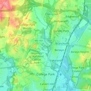
Name: Topografische Karte College Park, Höhe, Relief.
Durchschnittliche Höhe: 38 m
Minimale Höhe: 10 m
Maximale Höhe: 100 m
Spenden
Rüste dich für dein nächstes Abenteuer:
Als Amazon-Partner verdient diese Seite an qualifizierten Käufen, ohne dass Ihnen zusätzliche Kosten entstehen.
Andere topografische Karten
Klicken Sie auf eine Karte, um ihre Topografie, ihre Höhe und ihr Relief anzuzeigen.
Stafford
United States > Maryland > Prince George's County > East Riverdale
Durchschnittliche Höhe: 42 m
Sellman Estates
United States > Maryland > Prince George's County > Beltsville
Durchschnittliche Höhe: 61 m
Spenden
Rüste dich für dein nächstes Abenteuer:
Als Amazon-Partner verdient diese Seite an qualifizierten Käufen, ohne dass Ihnen zusätzliche Kosten entstehen.
Spenden
Rüste dich für dein nächstes Abenteuer:
Als Amazon-Partner verdient diese Seite an qualifizierten Käufen, ohne dass Ihnen zusätzliche Kosten entstehen.
Spenden
Rüste dich für dein nächstes Abenteuer:
Als Amazon-Partner verdient diese Seite an qualifizierten Käufen, ohne dass Ihnen zusätzliche Kosten entstehen.
Spenden
Rüste dich für dein nächstes Abenteuer:
Als Amazon-Partner verdient diese Seite an qualifizierten Käufen, ohne dass Ihnen zusätzliche Kosten entstehen.
Mount Rainier Neighborhood Park
United States > Maryland > Prince George's County > Mount Rainier
Durchschnittliche Höhe: 21 m
Farmington Road Estates
United States > Maryland > Prince George's County > Farmington Road Estates
Durchschnittliche Höhe: 47 m
Spenden
Rüste dich für dein nächstes Abenteuer:
Als Amazon-Partner verdient diese Seite an qualifizierten Käufen, ohne dass Ihnen zusätzliche Kosten entstehen.